No man's land
No man's land is land that is unoccupied or is under dispute between parties who leave it unoccupied due to fear or uncertainty. The term was originally used to define a contested territory or a dumping ground for refuse between fiefdoms.[1] In modern times, it is commonly associated with the First World War to describe the area of land between two enemy trench systems, which neither side wished to cross or seize due to fear of being attacked by the enemy in the process.[2]
Origin
According to Alasdair Pinkerton, an expert in human geography at the Royal Holloway University of London, the word "first appears in the Domesday Book in the late 1000s to describe parcels of land that lie just beyond the London city walls".[3] The Oxford English Dictionary contains a reference to the term dating back to 1320, and spelled nonesmanneslond, when the term was used to describe a disputed territory or one over which there was legal disagreement.[1][4] The same term was later used as the name for the piece of land outside the north wall of London that was assigned as the place of execution.[4] The term was applied to a little-used area on ships called the forecastle, a place where various ropes, tackle, block, and other supplies were stored.[5] In the United Kingdom several places called No Man's Land denoted "extra-parochial spaces that were beyond the rule of the church, beyond the rule of different fiefdoms that were handed out by the king … ribbons of land between these different regimes of power".[3]
World War I
The British Army did not widely employ the term when the Regular Army arrived in France in August 1914, soon after the outbreak of the Great War.[6] The terms used most frequently at the start of the war to describe the area between the trench lines included 'between the trenches' or 'between the lines'.[6] The term 'no man's land' was first used in a military context by soldier and historian Ernest Swinton in his short story The Point of View.[1] Swinton used the term in war correspondence on the Western Front, with specific mention of the terms with respect to the Race to the Sea in late 1914.[6] The Anglo-German Christmas truce of 1914 brought the term into common use, and thereafter it appeared frequently in official communiqués, newspaper reports, and personnel correspondences of the members of the British Expeditionary Force.[6]
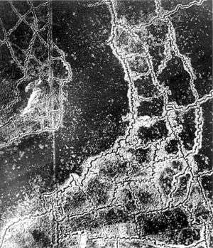
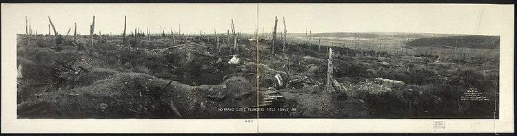
In World War I, no man's land often ranged from several hundred yards to in some cases less than 10 yards.[7] Heavily defended by machine guns, mortars, artillery and riflemen on both sides, it was often riddled with barbed wire and rudimentary improvised land mines, as well as corpses and wounded soldiers who were not able to make it across the sea of explosions and fire. The area was usually devastated by the warfare, carnage and remains of the artillery. It was open to fire from the opposing trenches and hard going generally slowed down any attempted advance. However, not only were soldiers forced to cross no man's land when advancing, and as the case might be when retreating, but after an attack the stretcher bearers would need to go out into it to bring in the wounded. No man's land remained a regular feature of the battlefield until near the end of World War I, when mechanized weapons (i.e. tanks) made entrenched lines less of an obstacle.
Effects from World War I no man's lands persist today, for example at Verdun in France, where the Zone Rouge (Red Zone) is an area with unexploded ordnance, poisoned beyond habitation by arsenic, chlorine, and phosgene. The zone is sealed off completely and still deemed too dangerous for civilians to return to: "The area is still considered to be very poisoned, so the French government planted an enormous forest of black pines, like a living sarcophagus", comments Alasdair Pinkerton, a researcher at Royal Holloway University of London, who compared the zone to the nuclear disaster site at Chernobyl, similarly encased in a "concrete sarcophagus".[3]
Cold War
During the Cold War, one example of "no man's land" was the territory close to the Iron Curtain. Officially the territory belonged to the Eastern Bloc countries, but over the entire Iron Curtain there were several wide tracts of uninhabited land, several hundred meters in width, containing watch towers, minefields, unexploded bombs and other such debris.
The U.S. Naval Base at Guantánamo Bay, Cuba is separated from Cuba proper by an area called the Cactus Curtain. In late 1961, Cuba had its troops plant an 8-mile (13 km) barrier of Opuntia cactus along the northeastern section of the 28-kilometre (17 mi) fence surrounding the base to prevent economic migrants from fleeing Cuba from resettling in the United States.[8] This was dubbed the "Cactus Curtain", an allusion to Europe's Iron Curtain[9] and the Bamboo Curtain in East Asia. U.S. and Cuban troops placed some 55,000 land mines across the no man's land, creating the second-largest minefield in the world, and the largest in the Americas. On 16 May 1996, Bill Clinton, the President of the United States, ordered their removal. The U.S. land mines have since been replaced with motion and sound sensors to detect intruders. The Cuban government has not removed the corresponding minefield on its side of the border.
Israel-Jordan
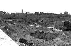
The 1949 Armistice Agreements between Israel and Jordan were signed in Rhodes with the help of UN mediation on 3 April 1949.[10] Armistice lines were determined in November 1948. Between the lines territory was left that was defined as no man's land.[11][12] Such areas existed in Jerusalem, in the area between the western and southern parts of the Walls of Jerusalem and Musrara.[13] A strip of land north and south of Latrun was also known as "no man's land" because it was not controlled by either Israel or Jordan in 1948-1967.[14]
Oklahoma Panhandle
In 1885, the United States Interior Department ruled that what was called "The Neutral Strip" was public land and that squatter homesteads were invalid. The Strip began to be called No Man's Land around 1886 after one official stated "no man can own the land".[15]
See also
References
- Notes
- 1 2 3 Persico p. 68
- ↑ Coleman p. 268
- 1 2 3 "Adventures in No Man's Land - BBC News", Bbc.com, retrieved 30 September 2015
- 1 2 Levenback p. 95
- ↑ Hendrickson, Robert Facts on File Dictionary of Word and Phrase Origins (2008)
- 1 2 3 4 Payne, David (8 July 2008). "No Man's Land". Western Front Association. Retrieved 20 November 2009.
- ↑ Hamilton, John (2003), Trench Fighting of World War I, ABDO, p. 8, ISBN 1-57765-916-3
- ↑ "Guantanamo Bay Naval Base and Ecological Crises". Trade and Environment Database. American University. Retrieved 2009-04-19.
- ↑ "Yankees Besieged". TIME. 1962-03-16.
- ↑ http://unispal.un.org/UNISPAL.NSF/0/F03D55E48F77AB698525643B00608D34
- ↑ http://www.mfa.gov.il/NR/rdonlyres/CD41289E-0875-4D84-A2D1-5BBF34BCF91A/0/mapstorypart2.pdf
- ↑ http://www.mfa.gov.il/MFA/Facts+About+Israel/Israel+in+Maps/1949+Armistice+Agreement+with+Jordan.htm
- ↑ Reclaiming Jerusalem's no-man's-land
- ↑ Palestinians for Peace and Democracy
- ↑ "The Panhandle of Oklahoma before statehood". No Mans Land Historical society. Retrieved 21 April 2014.
- Bibliography
- Coleman, Julie (2008). A History of Cant and Slang Dictionaries. 3. Oxford University Press. ISBN 0-19-954937-0.
- Persico, Joseph E. (2005). Eleventh Month, Eleventh Day, Eleventh Hour: Armistice Day, 1918 World War I and Its Violent Climax. Random House. ISBN 0-375-76045-8.