Nonouti
 Map of Nonouti | |||||
 | |||||
| Geography | |||||
|---|---|---|---|---|---|
| Location | Pacific Ocean | ||||
| Coordinates | 0°40′S 174°20′E / 0.667°S 174.333°E | ||||
| Archipelago | Gilbert Islands | ||||
| Area | 21.02 km2 (8.12 sq mi) | ||||
| Highest elevation | 3 m (10 ft) | ||||
| Administration | |||||
| Demographics | |||||
| Population | 2,683 (2010 Census) | ||||
| Pop. density | 135 /km2 (350 /sq mi) | ||||
| Ethnic groups | I-Kiribati 99.7% | ||||
| Additional information | |||||
| |||||

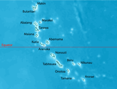
Nonouti is an atoll and district of Kiribati. The atoll is located in the South Gilbert Islands, 38 km north of Tabiteuea, and 250 km south of Tarawa. The atoll is the third largest in the Gilbert Islands and is the island where the Catholic religion was first established in Kiribati, in 1888.
Geography
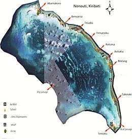
The eastern side of the atoll is the primary permanent landmass. There is an islet on the northwest side of the atoll called Noumatong, which is uninhabited and is reserved as a bird sanctuary. The eastern area of the atoll consists of tiny islets and islands which form a continuous line.[1]
Villages
The government station on the island is located in the village of Matang. The island clerk is the highest ranking government official on the island. The former president, Ieremia Tabai, is from Nonouti.
Nonuti hosts seven primary schools and one Junior Secondary School, and is home to George Eastman High School, run privately by the Kiribati Protestant Church.[1]
The land area of Nonouti islets, and village populations, are:
| Nonouti: Population and Land Area | |||
| Census Area | Population 2010[2] | Land area by islet[2] | Density (people per hectare) |
|---|---|---|---|
| Abamakoro | 104 | 185 hectares (457 acres) | 0.6 |
| Benuaroa | 84 | 108 hectares (267 acres) | 0.8 |
| Teuabu | 269 | 150 hectares (371 acres) | 1.9 |
| Temanoku | 286 | 562 hectares (1,389 acres) | 0.9 |
| Rotuma | 405 | ||
| Autukia | 112 | ||
| Matang | 537 | 811 hectares (2,004 acres) | 1.5 |
| Taboiaki | 692 | ||
| Temotu | 194 | 138 hectares (341 acres) | 1.4 |
| Nonouti total | 2683 | 1,988 hectares (4,912 acres) | 1.3 |
History
In the late 19th century, Nonouti was briefly conquered by the king of Abemama, Tembinok'. The latter was driven out of Nonouti by a British warship.[3]
The first Catholic missionaries were Tahiti-based Frenchmen, who arrived on the island of Nonouti, Gilbert Islands in the early 1880s and began translating texts and compiling dictionaries.[4] The first priests in the Gilbert Islands, members of the Missionaries of the Sacred Heart, left France in 1888 and arrived on Nonouti on 10 May 1888.[4] They arrived to find quite a large number of Gilbertese who were already exposed to the Gospel.[4] Many of the Gilbertese natives had been taken by blackbirders in the 1870s to work on plantations on other islands in the Pacific, where they were met by Protestant missionaries.[4] Two of these laborers, Betero and Tiroi, returned to Nonouti and instructed the local people about Christianity.[4] They built churches, where people assembled each Sunday to sing hymns and recite prayers.[4] At the time of the arrival of the Missionaries of the Sacred Heart, Betero and Tiroi had already baptized 560 people and were instructing and additional 600.[4]
Close to where the first Catholic missionaries arrived in 1888, just behind the apse of the Catholic Church in Taboiaki village, are the six graves of important foreign missionaries and people to the Catholic Church. Opposite this Catholic Church is the biggest maneaba in Kiribati known as the Aake Maneaba.
Nonouti Post Office opened around 1923.[5]
References
- 1 2 "11. Nonouti" (PDF). Office of Te Beretitent - Republic of Kiribati Island Report Series. 2012. Retrieved 28 April 2015.
- 1 2 "Kiribati Census Report 2010 Volume 1" (PDF). National Statistics Office, Ministry of Finance and Economic Development, Government of Kiribati.
- ↑ Stevenson, Robert Louis (1987) [1896]. In the South Seas, Part V, Chapter 1. Chatto & Windus; republished by The Hogarth Press.
- 1 2 3 4 5 6 7 "History of the Diocese of Tarawa and Nauru - MSC Pacific Union". pacificunion.mscmission.org. Retrieved 2016-06-30.
- ↑ Premier Postal History. "Post Office List". Premier Postal Auctions. Retrieved 5 July 2013.
- Exhibit: The Alfred Agate Collection: The United States Exploring Expedition, 1838-1842 from the Navy Art Gallery
| Gilbert Islands |  | |
|---|---|---|
| Phoenix Islands | ||
| Line Islands | ||
| West of Gilberts | ||
| Reefs | ||
| ||
Coordinates: 0°37′S 174°22′E / 0.617°S 174.367°E