Nordfjorden (Sogn og Fjordane)
| Nordfjorden | |
|---|---|
| Nordfjord | |
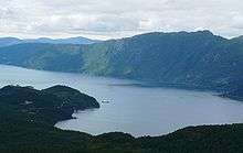
 View of the fjord | |
 Norfjorden Location in Sogn og Fjordane county | |
| Location | Nordfjord, Sogn og Fjordane |
| Coordinates | 61°53′47″N 5°16′33″E / 61.8963°N 5.2759°ECoordinates: 61°53′47″N 5°16′33″E / 61.8963°N 5.2759°E |
| Basin countries | Norway |
| Max. length | 106 kilometres (66 mi) |
| Max. width | 2.5 kilometres (1.6 mi) |
| Max. depth | 565 metres (1,854 ft) |
| Islands | Husevågøy |
| Settlements | Måløy |
Nordfjorden is the sixth longest fjord in Norway and the second longest fjord in all of Sogn og Fjordane county. It flows through the municipalities of Stryn, Gloppen, Eid, Bremanger, and Vågsøy, and it is the central feature of the entire Nordfjord region which makes up the northern third of the county.

The 106-kilometre (66 mi) long fjord stretches from Husevågøy island in Vågsøy Municipality to the village of Loen in Stryn Municipality. The fjord starts as runoff from the Jostedalsbreen, Europe's largest mainland glacier, in the east and it flows west, emptying into the ocean just south of the Stadlandet peninsula. The mouth of the fjord lies between the large islands of Vågsøy and Bremangerlandet (with the smaller island of Husevågøy lying in the middle of the mouth).
There are several smaller fjords which branch off the main Nordfjorden: Eidsfjorden, Ålfotfjorden, Hyefjorden, and Gloppefjorden. The fjord reaches a maximum-depth of 565 metres (1,854 ft) near the mouth of the Eidsfjorden and also by the village of Bryggja.[1][2]
Transportation
The fjord has no road or rail crossings, but it has three regular ferry crossings. There is a ferry from Anda to Lote as part of the European route E39 highway. Another crossing is from Isane to Stårheim. The final crossing is near the mouth of the fjord from the town of Måløy to Oldeide. This final crossing also includes a stop at the island of Husevågøy in the middle of the fjord.
Settlements
There are numerous old fishing communities located along the fjord that date back to pre-Viking times. Some of the notable population centers along the fjord include the town of Måløy (near the north side of the mouth), the villages of Bryggja and Totland (in Vågsøy); Rugsund, Davik, and Ålfoten (in Bremanger); Kjølsdalen, Stårheim, Nordfjordeid, and Lote (in Eid); Sandane and Gimmestad (in Gloppen); and Randabygda, Utvik, Innvik, Roset, Stryn, Olden, and Loen (in Stryn).[1]
See also
References
- 1 2 Store norske leksikon. "Nordfjorden" (in Norwegian). Retrieved 2013-09-14.
- ↑ "The Nordfjord". VisitNorway.com. Retrieved 2013-09-14.