North Carolina Highway 10
| ||||
|---|---|---|---|---|
 | ||||
| Route information | ||||
| Maintained by NCDOT | ||||
| Length: | 48.3 mi[1] (77.7 km) | |||
| Existed: | 1921 – present | |||
| Major junctions | ||||
| West end: |
| |||
|
| ||||
| East end: |
| |||
| Location | ||||
| Counties: | Cleveland, Lincoln, Catawba | |||
| Highway system | ||||
| ||||

North Carolina Highway 10 (NC 10) is a primary state highway in the U.S. state of North Carolina. Originally established as the state's central highway, from Murphy to Beaufort. Nowadays, it serves to connect the city of Newton with the nearby communities and towns in the foothills region.
Route description
Catawba County
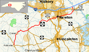
NC 10's eastern terminus is at Interstate 40 (exit 138) in Catawba County, just southwest of Statesville and just northeast from Claremont. From this point, NC 10 travels in a southerly (signed west) direction as Oxford School Road, crossing US 70 and entering the town of Catawba. As Main Street, NC 10 travels through the heart of the town and turns right on Second Avenue. Exiting the town to the southwest, NC 10 travels to the city of Newton where it merges with NC 16 for a short while and takes the name of D Street, and later C Street. After leaving Newton, NC 10 has an interchange with the US 321 freeway and meets a terminus of NC 127 before crossing the county line.
Lincoln County
After NC 10 enters Lincoln County, it meets NC 18 in the community of Laurel Hill. NC 18 and NC 10 are concurrent for about a one-mile (1.6 km) stretch before NC 10 splits in a westerly direction. The route then crosses another county line.
Cleveland County
Shortly after passing into Cleveland County, NC 10 meets the western terminus of NC 27, one of the state's longest state highways. Curving through the North Carolina foothills as Casar Road, NC 10 passes through the town of Casar, and eventually arrives in Polkville. There, NC 10 meets its southern terminus at NC 226 in the center of town.
History
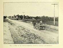
- 1911: North Carolina state legislation brings the Central Highway project into being. The Central Highway was a conceived plan for a continuous highway that stretched from the westernmost portions of North Carolina to the coast.[2][3]
- Late 1910s: The second and third State Highway Commissions surveyed a route for NC 10, which was the number designated for the Central Highway. Existing roads were linked with new roads to form the east–west route.
- 1924: About one-half of the Central Highway was paved at this point; the rest remained as clay or gravel roads.
- 1926: Nearly all of NC 10 was paved. Also, many citizens of Newton, who were upset that the Central Highway was not routed through their city, took the State Highway Commission to court. The case was finally decided in the North Carolina Supreme Court, which ruled that NC 10 must pass by the Newton courthouse. The already constructed NC 10 bypassing Newton was given the designation NC 110, and most travelers took this bypass anyway.
- 1927: U.S. Highways arrived in North Carolina; US 70 and US 19 shared much of NC 10's routing.
- 1929: Both NC 10 and NC 110 were completely paved.
- 1930: NC 110 was renamed NC 10A
- 1933: North Carolina eliminated most state highways that coincided with U.S. highways. Most of NC 10 is truncated.
- 1932: US 70 moved from NC 10's former routing to NC 10A, replacing it completely in the Newton area. NC 10 reoccupied its routing east of Newton.
- 1938: NC 10 is extended west to terminate at NC 18.
- 1940: NC 10 is extended west again to end at its current western terminus in Polkville.
- Mid 1990s: NC 10's eastern terminus is extended about one mile (1.6 km) north from US 70 to I-40.
Part of an early routing of NC 10 is still visible in Orange county. Just east of Mebane, previous NC 10 ran parallel to current I-40/85, just a mile south of the highway. At Efland, the road crossed the interstate and ran parallel route just north of the current interstate on Ben Johnson Road. The road followed the Eno River to Hillsborough and turned left on King St. (no longer an intersection). The route turned right onto Churton St. (NC 86), and turned eastward after crossing the interstate and followed the railroad to a junction to US 70 at the Durham County Line.
There is a two-block section of NC 10 in Buncombe County, in Black Mountain. The segment runs north of and parallel to E. State Street (between Black Mountain and Ridgecrest) and I-40. In a residential neighborhood, the street is named "Old State Ten Road."
Major intersections
| County | Location | mi | km | Destinations | Notes |
|---|---|---|---|---|---|
| Cleveland | Polkville | 0.0 | 0.0 | Southern terminus | |
| Toluca | 14.8 | 23.8 | Western terminus of NC 27 | ||
| Lincoln | Laurel Hill | 15.7 | 25.3 | South end of NC 18 overlap | |
| 16.0 | 25.7 | North end of NC 18 overlap | |||
| Catawba | Propst Crossroads | 25.9 | 41.7 | Southern terminus of NC 127 | |
| Newton | 31.0 | 49.9 | Diamond interchange | ||
| 35.5 | 57.1 | ||||
| 36.0 | 57.9 | South end of NC 16 Bus. overlap; Pair of one-way streets, Main Avenue (SB), College Avenue (NB) | |||
| 36.9 | 59.4 | North end of NC 16 Bus. overlap | |||
| 37.9 | 61.0 | ||||
| Catawba | 46.7 | 75.2 | |||
| 48.4 | 77.9 | Northern terminus; I-40 Exit 138; Diamond interchange | |||
1.000 mi = 1.609 km; 1.000 km = 0.621 mi
| |||||
Bannered routes
Conover–Catawba alternate route
| |
|---|---|
| Location: | Conover–Catawba, NC |
| Existed: | 1930–1934 |
North Carolina Highway 10 Alternate (NC 10A) was a renumbering of NC 110, which bypassed Newton by traveling north through Claremont; it was in complete concurrency with US 70. In 1934, it was decommissioned in favor of US 70.
High Point alternate route
| |
|---|---|
| Location: | High Point |
| Existed: | 1933–1934 |
North Carolina Highway 10 Alternate (NC 10A) was established as a new alternate routing that bypassed north of downtown High Point, via Westchester Drive and Lexington Avenue; it was in complete concurrency with US 70. In 1934, it was decommissioned in favor of US 70.
Gibsonville–Burlington alternate route
| |
|---|---|
| Location: | Gibsonville–Burlington, NC |
| Existed: | 1932–1934 |
North Carolina Highway 10 Alternate (NC 10A) was a renumbering of NC 100, which traveled through Elon College. In 1934, it was reverted to NC 100.
See also
References
- ↑ Google (June 6, 2014). "North Carolina Highway 10" (Map). Google Maps. Google. Retrieved June 6, 2014.
- ↑ "Chapter 58. An act to provide for the construction and maintenance of a central highway". Public Laws for 1911. 1911.
- ↑ Pratt, Joseph Hyde (1912). Highway work in North Carolina : containing a statistical report of road work during 1911. Raleigh: E.M. Uzzell, State Printers. p. 18-26.
External links
-
 Media related to North Carolina Highway 10 at Wikimedia Commons
 - Filpus Roadgeek - Historic NC 10
- NCRoads.com: N.C. 10
- NCRoads.com: N.C. 10-A
- The Central Highway and early State Highway 10 (NC 10) through Orange County