North Carolina Highway 183
| ||||
|---|---|---|---|---|
 | ||||
| Route information | ||||
| Maintained by NCDOT | ||||
| Length: | 4.5 mi[1] (7.2 km) | |||
| Existed: | ca. 1930 – present | |||
| Tourist routes: |
| |||
| Major junctions | ||||
| West end: |
| |||
| East end: |
| |||
| Location | ||||
| Counties: | Burke, McDowell | |||
| Highway system | ||||
| ||||

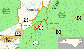
North Carolina Highway 183 (NC 183) is a primary state highway in the U.S. state of North Carolina. It traverses from US 221, in the community of Linville Falls, to NC 181, near the community of Jonas Ridge.
Route description

The route serves mainly as a connector between Linville Falls and the rest of Burke County; it also serves as an alternate route to the Blue Ridge Parkway, which parallels the route. The route also has access to the Linville Falls and Gorge Wilderness Area. Part of the route is shared with NC Bike Route 2.
Where NC 183 begins, it is flanked by nearby McDowell and Avery counties. The highway also crosses briefly into McDowell county twice, in to short successions, in Linville Falls. Nearly halfway along the highway, a spur road from the Blue Ridge Parkway does a fly-over above the highway (no access).[1]
NC 183, with continuation via NC 181, can be considered an alternate route of US 221, bypassing Altamont and Crossnore.
Scenic byways
NC 183 is part of one scenic byway in the state (indicated by a Scenic Byways sign).[2]
Pisgah Loop Scenic Byway is an 47-mile (76 km) loop byway, not recommended for recreational vehicles and bus with four-wheel drive required for unpaved portions. It is noted for its close proximity to the Blue Ridge Parkway, the Linville River and Falls, and a rare montane (mountain wetland). NC 183 makes up the northern segment of the loop, which also includes Old NC Highway 105 (SR 1238), NC 126, Fish Hatchery Road (SR 1254/SR 1240), and NC 181.[2]
History
NC 183 was established around 1930 as a new primary routing between NC 105 and NC 181, in northern Burke County.[3] In 1954, NC 183 replaced part of NC 105, into Linville Falls, to its current western terminus at US 221.[4]
Junction list
| County | Location | mi[1] | km | Destinations | Notes | |||
|---|---|---|---|---|---|---|---|---|
| Burke | Linville Falls | 0.0 | 0.0 | |||||
| McDowell |
No major junctions | |||||||
| Burke |
No major junctions | |||||||
| McDowell |
No major junctions | |||||||
| Burke | Jonas Ridge | 4.5 | 7.2 | |||||
| 1.000 mi = 1.609 km; 1.000 km = 0.621 mi | ||||||||
References
- 1 2 3 Google (February 1, 2011). "North Carolina Highway 183" (Map). Google Maps. Google. Retrieved February 1, 2011.
- 1 2 "North Carolina Scenic Byways" (PDF). North Carolina Department of Transportation. Retrieved May 16, 2015.
- ↑ State Highway System of North Carolina (PDF) (Map). Cartography by NCSHC. North Carolina State Highway Commission. 1930. Retrieved May 17, 2015.
- ↑ North Carolina County Road Survey 1953 (PDF) (Map). Cartography by NCHPWC / USPRA. North Carolina State Highway and Public Works Commission. 1953. Retrieved May 17, 2015.
External links
-
 Media related to North Carolina Highway 183 at Wikimedia Commons
 - NCRoads.com: N.C. 183