North Carolina Highway 215
| ||||
|---|---|---|---|---|
 | ||||
| Route information | ||||
| Maintained by NCDOT | ||||
| Length: | 44.0 mi[1] (70.8 km) | |||
| Existed: | 1967 – present | |||
| Tourist routes: |
| |||
| Major junctions | ||||
| South end: |
| |||
|
| ||||
| North end: |
| |||
| Location | ||||
| Counties: | Transylvania, Jackson, Haywood | |||
| Highway system | ||||
| ||||

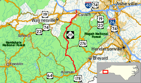
North Carolina Highway 215 (NC 215) is a highway in western North Carolina that runs from the town of Rosman in Transylvania County to Canton at Interstate 40 and U.S. Route 74 (US 74). The portion from Canton to Rosman is a part of the National Forest Service's Forest Heritage Scenic Byway. It travels high into the mountains along a scenic stretch of the upper West Fork of the Pigeon River, and intersects the Blue Ridge Parkway at Beech Gap at an elevation of approximately 5,300 feet (1,600 m).
Route description

History
The highway defines the boundaries of the Shining Rock and Middle Prong wildernesses: Shining Rock lying to the east, and Middle Prong to the west. The right-of-way for the highway is all that separates the two for several miles, and several hiking trails start along parking areas on this road or on spur roads connecting to it. Several waterfalls along the West Fork or its tributaries can be seen from the road itself, especially during the winter after rainfall. Some can be accessed by hiking trails, but others are very remote making hiking to them difficult even though they can clearly be seen from the highway. This section of road is popular with tourists and with motorcyclists due to its curvy nature.
NC 215 was built on the right of way of two logging railroads.
Future
North Carolina Department of Transportation plans to modernize a 5.04-mile (8.11 km) section of NC 215 between US 276 (Pigeon Road) to SR 1926 (Pisgah School Road). The project includes widening lanes to 12 feet (3.7 m) from the current 10 feet (3.0 m) and paved shoulders. At an estimated cost of $13.8 million, it is currently unfunded.[2]
Junction list
| County | Location | mi[1] | km | Destinations | Notes | |||
|---|---|---|---|---|---|---|---|---|
| Transylvania | | 0.0 | 0.0 | |||||
| Jackson |
No major junctions | |||||||
| Transylvania |
No major junctions | |||||||
| Haywood | | 17.1 | 27.5 | Blue Ridge Parkway | One-quadrant interchange | |||
| Woodrow | 35.0 | 56.3 | South end of US 276 overlap; southern terminus of NC 110 | |||||
| 35.8 | 57.6 | North end of US 276 overlap | ||||||
| Canton | 41.7 | 67.1 | North end of US 19/US 23 overlap | |||||
| 42.1 | 67.8 | South end of US 19/US 23 overlap | ||||||
| 44.0 | 70.8 | Exit 31 (I-40) | ||||||
1.000 mi = 1.609 km; 1.000 km = 0.621 mi
| ||||||||
References
- 1 2 Google (November 25, 2014). "North Carolina Highway 215" (Map). Google Maps. Google. Retrieved November 25, 2014.
- ↑ "SPOT ID: H110984" (PDF). North Carolina Department of Transportation. May 30, 2014. Retrieved July 10, 2014.
External links
 Media related to North Carolina Highway 215 at Wikimedia Commons
- NCRoads.com: N.C. 215
- Forest Heritage National Scenic Byway