North Carolina Highway 71
| ||||
|---|---|---|---|---|
 | ||||
| Route information | ||||
| Maintained by NCDOT | ||||
| Length: | 27.1 mi[1] (43.6 km) | |||
| Existed: | 1928[2] – present | |||
| Major junctions | ||||
| South end: |
| |||
|
| ||||
| North end: |
| |||
| Location | ||||
| Counties: | Robeson, Scotland | |||
| Highway system | ||||
| ||||

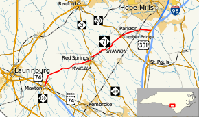
North Carolina Highway 71 (NC 71) is a state highway that serves the communities of Maxton, Red Springs, Shannon, Lumber Bridge, and Parkton. Most of the highway travels through Robeson County but a short portion of it passes through Scotland County.
Route description
The southern terminus of the route is U.S. Route 74 Business (US 74 Bus.)[3] and Martin Luther King Drive in central Maxton. This point is also the western terminus of NC 130 from there the route follows North Patterson St to the US 74 / Future Interstate 74 interchange (exit 191 on US 74). Shortly after leaving town, the route has a brief incursion into Scotland County, it returns to Robeson County by crossing the Lumber River. After passing through the community of Wakulla, the route has a brief concurrency with NC 211 in the town of Red Springs. After the split from NC 211, NC 71 continues northeast to Shannon. To the north the highway serves Lumber Bridge, where it intersects NC 20, and Parkton. The northern terminus of the route is US 301, just outside Parkton.[1]
History
The route was created in 1928 running from Maxton to Red Springs. In 1930 the route was extended, receiving a southern terminus in Rowland, and its current northern terminus with present-day US 301. The southern terminus of the route was again extended in 1931 reaching modern-day NC 41 just south of Fairmont. In the 1940s, NC 71 south of Maxton was resigned as NC 130, receiving its current routing.[2]
Junction list
| County | Location | mi[1] | km | Destinations | Notes | |||
|---|---|---|---|---|---|---|---|---|
| Robeson | Maxton | 0.0 | 0.0 | Western terminus of NC 130 | ||||
| 0.9– 1.1 | 1.4– 1.8 | Exit 191 (US 74) | ||||||
| Scotland |
No major junctions | |||||||
| Robeson | Red Springs | 12.1 | 19.5 | Southern end of NC 211 concurrency | ||||
| 12.8 | 20.6 | Northern end of NC 211 concurrency | ||||||
| Lumber Bridge | 20.6 | 33.2 | ||||||
| | 27.1 | 43.6 | ||||||
1.000 mi = 1.609 km; 1.000 km = 0.621 mi
| ||||||||
References
- 1 2 3 Google (February 15, 2016). "North Carolina Highway 71" (Map). Google Maps. Google. Retrieved February 15, 2016.
- 1 2 "NCRoads.com N.C. 71". Archived from the original on September 21, 2011. Retrieved 2011-10-04.
- ↑ "NC State Highway 71 Ends". Archived from the original on July 12, 2011. Retrieved 2011-10-04.
External links
-
 Media related to North Carolina Highway 71 at Wikimedia Commons
 - NCRoads.com: N.C. 71