North Carolina Highway 79
| ||||
|---|---|---|---|---|
| Gibson Road | ||||
 | ||||
| Route information | ||||
| Maintained by NCDOT | ||||
| Length: | 8.7 mi[1] (14.0 km) | |||
| Existed: | 1934 – present | |||
| Major junctions | ||||
| South end: |
| |||
|
| ||||
| North end: |
| |||
| Location | ||||
| Counties: | Scotland | |||
| Highway system | ||||
| ||||

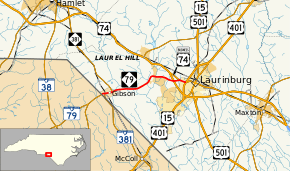
North Carolina Highway 79 (NC 79) is a 9-mile-long (14 km) North Carolina state highway running from the South Carolina border at Gibson to U.S. Routes 15, 401, and 501 in Laurinburg.
Junction list
The entire route is in Scotland County.
| Location | mi[1] | km | Destinations | Notes | |
|---|---|---|---|---|---|
| Gibson | 0.0 | 0.0 | South Carolina state line | ||
| 0.3 | 0.48 | Southern end of NC 381 concurrency | |||
| 1.1 | 1.8 | Northern end of NC 381 concurrency | |||
| | 7.5 | 12.1 | Exit 182 (US 74), eastbound entrance / westbound exit only; future I-74 | ||
| | 8.0 | 12.9 | Southern end of US 74 Bus. concurrency | ||
| Laurinburg | 8.7 | 14.0 | Interchange; northern end of US 74 Bus. concurrency | ||
1.000 mi = 1.609 km; 1.000 km = 0.621 mi
| |||||
See also
- U.S. Bicycle Route 1 - Concurrent with NC 79 in Springfield
References
- 1 2 Google (December 28, 2012). "North Carolina Highway 79" (Map). Google Maps. Google. Retrieved December 28, 2012.
External links
 Media related to North Carolina Highway 79 at Wikimedia Commons
- NCRoads.com: N.C. 79
This article is issued from Wikipedia - version of the 2/19/2016. The text is available under the Creative Commons Attribution/Share Alike but additional terms may apply for the media files.