North Carolina Highway 905
| ||||
|---|---|---|---|---|
 | ||||
| Route information | ||||
| Maintained by NCDOT | ||||
| Length: | 20.9 mi[1] (33.6 km) | |||
| Existed: | 1958 – present | |||
| Major junctions | ||||
| South end: |
| |||
| North end: |
| |||
| Location | ||||
| Counties: | Columbus | |||
| Highway system | ||||
| ||||

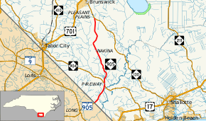
North Carolina Highway 905 (NC 905) is a primary state highway in the state of North Carolina. It serves as part of an alternate route between Whiteville and Conway, South Carolina, through southeastern Columbus County.
Route description
NC 905 is a two-lane rural highway that begins at the South Carolina line and South Carolina Highway 905 (SC 905) in Olyphic. Traveling north, it connects with NC 904 in Pireway. After its six-tenths-mile (0.97 km) concurrency with NC 904, it continues solo for 15.1 miles (24.3 km), connecting the communities of Bug Hill and Nakina, until it ends at NC 130 in Pleasant Plains.[1]
The route is part of a larger alternate route to U.S. Route 701 between Whiteville, North Carolina and Conway, South Carolina via NC 130 and SC 905. From 1958 to 2016, it was the highest number signed as a primary route in North Carolina.
History
NC 905 was established around 1958 as an extension of SC 905, which had ended at the state line since around 1942. Its route from Olyphic to Pleasant Plains has remained unchanged since.[2]
Junction list
The entire route is in Columbus County.
| Location | mi[1] | km | Destinations | Notes | |
|---|---|---|---|---|---|
| Olyphic | 0.0 | 0.0 | Continuation into South Carolina | ||
| Pireway | 4.5 | 7.2 | East end of NC 904 overlap | ||
| 5.1 | 8.2 | West end of NC 904 overlap | |||
| Pleasant Plains | 20.9 | 33.6 | |||
| 1.000 mi = 1.609 km; 1.000 km = 0.621 mi | |||||
References
- 1 2 3 Google (February 14, 2016). "North Carolina Highway 905" (Map). Google Maps. Google. Retrieved February 14, 2016.
- ↑ North Carolina Highway System (PDF) (Map). Cartography by NCSHC. North Carolina State Highway Commission. 1960. Retrieved February 14, 2016.
External links
 Media related to North Carolina Highway 905 at Wikimedia Commons
- NCRoads.com: N.C. 905