Norwegian National Road 13
| |
|---|---|
|
Norwegian: Riksvei 13 Nynorsk: Riksveg 13 | |
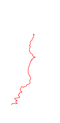  Location in Western Norway | |
| Route information | |
| Length: | 450 km (280 mi) |
| Major junctions | |
| North end: | Balestrand, Sogn og Fjordane |
| South end: | Sandnes, Rogaland |
| Highway system | |
| National Roads in Norway | |

National Road 13 (Norwegian: Riksvei 13) is a national road which runs from the town of Sandnes in Rogaland county to the municipality of Balestrand in Sogn og Fjordane county. The route is 449.9 kilometers (279.6 mi) long and runs north–south through Rogaland, Hordaland, and Sogn og Fjordane counties, following a more inland path than the European route E39 highway. From Balestrand to the town of Førde, the route continues as County Road 13. The route has three ferry crossings: Vangsnes to Dragsviki (across the Sognefjorden), Nesvik to Hjelmelandsvågen (across the Jøsenfjorden), and Oanes to Lauvika (across the Høgsfjorden). Parts of the road have been designated as National Tourist Routes.[1]
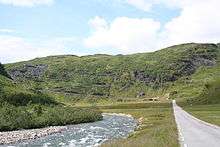
There are several tunnels on this highway; the longest of which are the Tunsberg Tunnel, Vallavik Tunnel, and Fresvik Tunnel. The Hardanger Bridge was completed in 2013, and it carries this highway across the large Hardangerfjorden.
Future improvements
A 14-kilometre (8.7 mi) long tunnel, Ryfast, is being built between Stavanger and Tau which will shorten the highway and it will also eliminated one ferry crossing. It will be finished in 2018, and be a part of National Road 13.
References
| Wikimedia Commons has media related to Riksveg 13. |
- ↑ "Nasjonal turistveg Ryfylke" (in Norwegian). Norwegian Public Roads Administration. Archived from the original on 5 October 2011. Retrieved 5 October 2011.
|  | |