Nowitna River
| Nowitna River | |
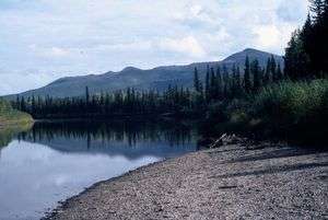 Gravel bar in the Nowitna National Wildlife Refuge | |
| Country | United States |
|---|---|
| State | Alaska |
| Census Area | Yukon–Koyukuk |
| Source | Kuskokwim Mountains |
| - elevation | 1,688 ft (515 m) [1] |
| - coordinates | 63°30′28″N 155°32′34″W / 63.50778°N 155.54278°W [2] |
| Mouth | Yukon River [3] |
| - location | 38 miles (61 km) northeast of Ruby |
| - elevation | 154 ft (47 m) [2] |
| - coordinates | 64°55′38″N 154°16′11″W / 64.92722°N 154.26972°WCoordinates: 64°55′38″N 154°16′11″W / 64.92722°N 154.26972°W [2] |
| Length | 250 mi (402 km) [3] |
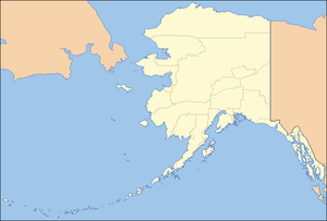 Location of the mouth of the Nowitna River in Alaska
| |
The Nowitna River is a 250-mile (400 km) tributary of the Yukon River in the U.S. state of Alaska.[3] The river flows northeast from the Kuskokwim Mountains through Nowitna National Wildlife Refuge and enters the larger river 38 miles (61 km) northeast of Ruby[3] and southwest of Tanana.[4] Major tributaries include the Titna, Big Mud, Little Mud, Lost, and Sulatna rivers.[4]
In 1980, the 225 miles (362 km) of the river within the wildlife refuge were designated "wild" and added to the National Wild and Scenic Rivers System.[5] The designation means that most of the Nowitna is unpolluted, free-flowing, and generally inaccessible except by trail.[6]
Boating
It is possible to run the Nowitna in many kinds of boats, including hard-shell, folding, or inflatable canoes and kayaks or inflatable rafts. Most of the river is slow-moving and meandering, rated Class I (easy) on the International Scale of River Difficulty. The exception occurs in Nowitna Canyon between Mastodon Creek and Big Mud River along the middle reaches of the Nowitna. This segment includes Class II (medium) rapids.[7]
Dangers include black bears as well as rapids. Navigating can be difficult at times because of upriver winds, especially on the lower reaches.[7]
See also
References
- ↑ Derived by entering source coordinates in Google Earth.
- 1 2 3 "Nowitna River". Geographic Names Information System. United States Geological Survey. January 1, 2000. Retrieved October 19, 2013.
- 1 2 3 4 Orth, Donald J.; United States Geological Survey (1971) [1967]. Dictionary of Alaska Place Names: Geological Survey Professional Paper 567 (PDF). University of Alaska Fairbanks. United States Government Printing Office. p. 705. Retrieved October 12, 2013.
- 1 2 Alaska Atlas & Gazetteer (7th ed.). Yarmouth, Maine: DeLorme. 2010. pp. 130 and 110–11. ISBN 978-0-89933-289-5.
- ↑ "Nowitna River, Alaska". National Wild and Scenic Rivers System. Retrieved October 19, 2013.
- ↑ "About the WSR Act". National Wild and Scenic Rivers System. Retrieved October 19, 2013.
- 1 2 Jettmar, Karen (2008) [1993]. The Alaska River Guide: Canoeing, Kayaking, and Rafting in the Last Frontier (3rd ed.). Birmingham, Alabama: Menasha Ridge Press. pp. 130–31. ISBN 978-0-89732-957-6.
External links
- Nowitna National Wildlife Refuge – U.S. Fish and Wildlife Service