Noxubee River
| Noxubee River | |
|---|---|
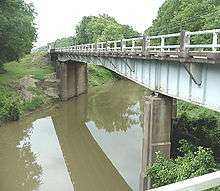 A bridge crossing of the Noxubee River at Macon, Mississippi | |
| Basin | |
| Main source |
619 ft (189 m) 33°18′12″N 89°08′51″W / 33.3033333°N 89.1475°W |
| River mouth |
75 ft (23 m) 32°49′42″N 88°10′45″W / 32.8283333°N 88.1791667°WCoordinates: 32°49′42″N 88°10′45″W / 32.8283333°N 88.1791667°W |
| Progression | Noxubee River → Tombigbee River → Mobile River → Gulf of Mexico |
| Physical characteristics | |
| Length | 91 mi (146 km) |
| Features | |
| GNIS ID | 158173 |
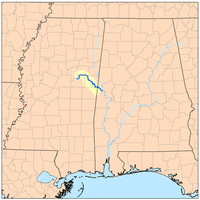
The Noxubee River (NAHKS-uh-bee) is a tributary of the Tombigbee River, about 90.6 miles (145.8 km) long, in east-central Mississippi and west-central Alabama in the United States.[1][2][3] Via the Tombigbee, it is part of the watershed of the Mobile River, which flows to the Gulf of Mexico.
Course
The Noxubee rises in Choctaw Lake in the Tombigbee National Forest in Choctaw County, Mississippi, and flows generally southeastwardly through Winston, Oktibbeha and Noxubee Counties in Mississippi, and Sumter County in Alabama, through the Noxubee National Wildlife Refuge and past the town of Macon, Mississippi. It joins the Tombigbee River from the west, about 2 mi (3 km) west of Gainesville, Alabama.
Variant names
According to the Geographic Names Information System, the Noxubee River has also been known as:
- Hachcha Osi River
- Hatch Oose River
- Hatcha River
- Hatchaoose River
- Hatche Oose River
- Hatchoose River
- Nooksabba River
- Noxaby Creek
- Noxiby River
- Noxshubby River
- Noxube River
- Noxuby Creek
- Oaknoxaby River
- Oaknoxubee River
- Ohanexubee River
- Oka Noxubee
- Oka Onoxubba River
- Okanoxubee River
- Okenoxubbee River
- Okenoxubee River
- Olamoyubee River
- Ruisseau Nachebe Tchitou River
See also
References
- ↑ "Noxubee River". Geographic Names Information System. United States Geological Survey. Retrieved 2015-09-13.
- ↑ "Noxubee River". Geographic Names Information System. United States Geological Survey. Retrieved 2015-09-13.
- ↑ "Station 02448000 NOXUBEE RIVER AT MACON, MS". USGS Hydro-Climatic Data Network (HCDN). United States Geological Survey (USGS). Retrieved 2015-09-13.
- DeLorme (1998). Alabama Atlas & Gazetteer. Yarmouth, Maine: DeLorme. ISBN 0-89933-274-9.
- DeLorme (1998). Mississippi Atlas & Gazetteer. Yarmouth, Maine: DeLorme. ISBN 0-89933-346-X.