Nura River
| Nura | |
| River | |
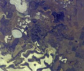 Mouth of the Nura River viewed from the International Space Station. Nura River cuts across the picture from upper right to just right of lower left. | |
| Country | Kazakhstan |
|---|---|
| Tributaries | |
| - left | Sherubainura |
| Cities | Karaganda, Temirtau, Kyzylzhar, Saran, Isen, Astana |
| Source | Kyzyltas Mountains |
| - location | Near Besoba |
| - elevation | 950 m (3,117 ft) |
| - coordinates | 48°56′N 74°23′E / 48.933°N 74.383°E |
| Mouth | Lake Tengiz |
| - elevation | 301 m (988 ft) |
| - coordinates | 50°20′34″N 69°08′21″E / 50.34278°N 69.13917°ECoordinates: 50°20′34″N 69°08′21″E / 50.34278°N 69.13917°E |
| Length | 978 km (608 mi) |
| Basin | 58,100 km2 (22,433 sq mi) |
| Discharge | |
| - average | 28.39 m3/s (1,003 cu ft/s) |
| - min | 0 m3/s (0 cu ft/s) |
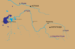 Map of the general area | |
The Nura River or River Nura is a major watercourse of northeast-central Kazakhstan. It is about 978 kilometres (608 mi) long and drains an area of 58,100 square kilometres (22,400 sq mi).
Course
The river rises in the Kyzyltas Mountains and flows initially north-northwestwards for about 100 kilometres (62 mi). It then turns to the west and flows in that direction for 220 kilometres (140 mi), then southwest for 180 kilometres (110 mi). The Nura turns north near Isen for about 200 kilometres (120 mi), eventually turning southwest as it draws close to Astana near the Irtysh River. From there, it flows southwest for almost 300 miles (480 km), through a series of lakes, finally ending in the endorheic Lake Tengiz. The river's largest tributaries are the Sherubainura, Ulkenkundyzdy, and Akbastau rivers. It is heavily used for irrigation and municipal water supply.[1] The average discharge at the mouth is 28.39 cubic metres per second (1,003 cu ft/s).[2]
The Irtysh–Karaganda Canal canal crosses the Nura at 50°05′26″N 73°22′40″E / 50.09056°N 73.37778°E, in what appears to be a tunnel. Some of the canals water is directed into the Nura (a chute below the dam at 50°5′30″N 73°22′37″E / 50.09167°N 73.37694°E), replenishing this river.
The Samarkand Reservoir is constructed on the Nura downstream from the canal crossing (the dam is at 50°06′17″N 72°55′08″E / 50.10472°N 72.91889°E), providing a waterfront for the city of Temirtau.
Pollution
In 1972, an acetaldehyde factory in the city of Temirtau began to discharge large quantities of mercury waste into the river. Although the factory closed in 1997, large amounts of mercury remain in the river and the area around it. Most of the mercury is spread in alluvial soils for a 25-kilometre (16 mi) stretch from Temirtau to the Intumak Reservoir, where most of the pollution was trapped. Despite that, significant levels of mercury are still found as far as 70 kilometres (43 mi) downstream and during high water, contaminants are spread all over the floodplain, creating a widespread problem. There is an estimated 1,500,000 cubic metres (53,000,000 cu ft) of contaminated soil surrounding the site. Ash from coal-fired power plants also pollutes the river.[3][4]
See also
References
- ↑ "Water Resources/Main river basins of Kazakhstan". Integrated Water Resource Management. United Nations Development Programme in Kazakhstan. Retrieved 2010-03-21.
- ↑ Rivers basins of Nura and Ishim — Drainage network (Map) (in Russian). Cartography by United Nations. United Nations Development Programme in Kazakhstan. Retrieved 2010-03-21.
- ↑ Sadykova, Dana (2007-04-02). "Mercury rising: The World Bank and the Nura river clean-up". Bretton Woods Project. Retrieved 2010-03-21.
- ↑ Heaven, S.; Ilyushchenko, M.A.; Kamberov, I.M.; Politikov, M.I.; Tanton, T.W.; Ullrich, S.M.; Yanin, E.P. (2000). "Mercury in the River Nura and its floodplain, Central Kazakhstan : II. Floodplain soils and riverbank silt deposits". Kazakh State Academy of Architecture and Construction, Almaty; Institute of New Chemical Technologies and Materials, Almaty; Kaskelen Geophysical Observatory, Almaty; Department of Civil and Environmental Engineering, University of Southampton; Institute of Mineralogy, Geochemistry and Crystallochemistry of Rare Elements, Moscow. Cat.inist. Retrieved 2010-03-21.