Ohio State Route 335
| ||||
|---|---|---|---|---|
 | ||||
| Route information | ||||
| Maintained by ODOT | ||||
| Length: | 42.41 mi[1] (68.25 km) | |||
| Existed: | 1933 – present | |||
| Major junctions | ||||
| South end: |
| |||
| North end: |
| |||
| Location | ||||
| Counties: | Scioto, Pike | |||
| Highway system | ||||
| ||||

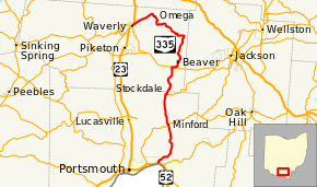
State Route 335 (SR 335) is a north–south state highway in the southern portion of the U.S. state of Ohio. Its southern terminus is at US 52 in Sciotoville, a neighborhood within the city of Portsmouth, and its northern terminus is at SR 220 in Waverly where it is concurrent with US 23 and SR 104 for 0.35 miles (0.56 km).
Route description

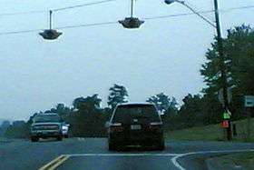
Scene in Beaver
Along the way, it intersects with SR 139 in Minford and SR 776 near Stockdale. It crosses SR 32 and SR 124 near Beaver.
History
SR 335 was commissioned in 1932, on it current route between Minford and Beaver.[2][3] The highway was extended to Waverly in 1937.[4][5] In 1939, the route was extended south to Portsmouth.[6][7]
Major intersections
| County | Location | mi[1] | km | Destinations | Notes |
|---|---|---|---|---|---|
| Scioto | Portsmouth | 0.00– 0.42 | 0.00– 0.68 | No eastbound entrance to US 52 | |
| Minford | 9.28 | 14.93 | |||
| Madison Township | 15.39 | 24.77 | Southern terminus of SR 776 | ||
| Pike | Marion Township | 21.25 | 34.20 | ||
| Waverly | 42.06 | 67.69 | Northern end of US 23 and SR 104 concurrency | ||
| 42.41 | 68.25 | Southern end of US 23 and SR 104 concurrency | |||
1.000 mi = 1.609 km; 1.000 km = 0.621 mi
| |||||
References
- 1 2 Ohio Department of Transportation. "Technical Services Straight Line Diagrams". Retrieved April 30, 2010.
- ↑ Ohio Department of Highways (1931). Map of Ohio Showing State Routes (MrSID) (Map). 1:760,320. Columbus: Ohio Department of Highways. OCLC 5673562, 7231737. Retrieved October 24, 2013.
- ↑ Ohio Department of Highways (1932). Map of Ohio Showing State Routes (MrSID) (Map). 1:760,320. Columbus: Ohio Department of Highways. OCLC 5673562, 7231704. Retrieved October 24, 2013.
- ↑ Ohio Department of Highways (1936). Official Highway Map of Ohio (MrSID) (Map). 1:760,320. Columbus: Ohio Department of Highways. OCLC 5673562. Retrieved October 24, 2013.
- ↑ Ohio Department of Highways (1937). Official Highway Map of Ohio (MrSID) (Map). 1:633,600. Columbus: Ohio Department of Highways. OCLC 5673562, 16960304. Retrieved October 24, 2013.
- ↑ Ohio Department of Highways (1938). Official Highway Map of Ohio (MrSID) (Map). 1:633,600. Columbus: Ohio Department of Highways. OCLC 5673562, 7453129. Retrieved October 24, 2013.
- ↑ Ohio Department of Highways (1939). Official Highway Map of Ohio (MrSID) (Map). 1:633,600. Columbus: Ohio Department of Highways. OCLC 5673562, 7408341. Retrieved October 24, 2013.
This article is issued from Wikipedia - version of the 1/11/2016. The text is available under the Creative Commons Attribution/Share Alike but additional terms may apply for the media files.