Ohio State Route 148
| ||||
|---|---|---|---|---|
 | ||||
| Route information | ||||
| Maintained by ODOT | ||||
| Length: | 26.97 mi[1] (43.40 km) | |||
| Existed: | 1923 – present | |||
| Major junctions | ||||
| West end: |
| |||
| East end: |
| |||
| Location | ||||
| Counties: | Belmont | |||
| Highway system | ||||
| ||||

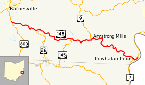
State Route 148 (SR 148) is an east–west state highway in eastern Ohio. Existing entirely in the southern portion of Belmont County, SR 148 has its western terminus at SR 800 approximately two miles (3.2 km) south of Barnesville. The eastern terminus of SR 148 is at SR 7 in Powhatan Point. From the SR 26 intersection easterly to its endpoint at SR 7, SR 148 generally runs in parallel to the Captina Creek.
In Powhatan Point, SR 148 intersects SR 7 twice. The signed portion of SR 148 comes to an end at the first (southernmost) intersection with SR 7. However, the Ohio Department of Transportation defines SR 148 as continuing as an unsigned route through Powhatan Point, following Front Street, Water Street, Fillmore Street, Second Street and Main Street through the village to its defined eastern terminus at its northern junction with SR 7 in the northern end of the village.
Route description
No part of SR 148 is incorporated within the National Highway System.[2]
History
SR 148 was commissioned in 1923, between Cambridge and Powhatan Point.[3][4] In 1927, the western terminus was moved to its current location, south of Barnesville.[5][6] The western terminus was extended west to an intersection with SR 147, in 1939.[7][8] Between 1942 and 1944 the western terminus was moved back to its current location.[9][10]
Major intersections
The entire route is in Belmont County.
| Location | mi[1] | km | Destinations | Notes | |
|---|---|---|---|---|---|
| Warren Township | 0.00 | 0.00 | Western terminus | ||
| Wayne Township | 5.56 | 8.95 | Northern terminus of SR 26 | ||
| Washington Township | 11.78 | 18.96 | Northern terminus of SR 145 | ||
| 15.59 | 25.09 | Southern terminus of SR 9 | |||
| Powhatan Point | 25.71 | 41.38 | Eastern end of signed portion of SR 148 | ||
| 26.97 | 43.40 | Eastern overall terminus | |||
| 1.000 mi = 1.609 km; 1.000 km = 0.621 mi | |||||
References
- 1 2 "DESTAPE - Belmont County" (PDF). Ohio Department of Transportation. June 24, 2015. Retrieved November 10, 2015.
- ↑ National Highway System: Ohio (PDF) (Map). Federal Highway Administration. December 2003. Retrieved 2010-06-06.
- ↑ Ohio Department of Highways and Public Works (April 1922). Map of Ohio State Highways (MrSID) (Map). Columbus: Ohio Department of Highways and Public Works. Retrieved October 22, 2013.
- ↑ Ohio Department of Highways and Public Works (July 1923). Map of Ohio Showing State Routes (MrSID) (Map). 1:760,320. Columbus: Ohio Department of Highways and Public Works. Retrieved October 22, 2013.
- ↑ Ohio Department of Highways and Public Works (August 1, 1926). Map of Ohio Showing State Routes (MrSID) (Map). 1:760,320. Columbus: Ohio Department of Highways and Public Works. OCLC 5673562. Retrieved October 22, 2013.
- ↑ Ohio Department of Highways and Public Works (June 1, 1927). Map of Ohio Showing State Routes (MrSID) (Map). 1:760,320. Columbus: Ohio Department of Highways and Public Works. OCLC 5673562. Retrieved October 22, 2013.
- ↑ Ohio Department of Highways (1938). Official Highway Map of Ohio (MrSID) (Map). 1:633,600. Columbus: Ohio Department of Highways. OCLC 5673562, 7453129. Retrieved October 22, 2013.
- ↑ Ohio Department of Highways (1939). Official Highway Map of Ohio (MrSID) (Map). 1:633,600. Columbus: Ohio Department of Highways. OCLC 5673562, 7408341. Retrieved October 22, 2013.
- ↑ Ohio Department of Highways (1942). Official Highway Map of Ohio (MrSID) (Map). 1:633,600. Columbus: Ohio Department of Highways. OCLC 5673562, 54667349. Retrieved October 22, 2013.
- ↑ Ohio Department of Highways (1944). Official Highway Map of Ohio (MrSID) (Map). 1:633,600. Columbus: Ohio Department of Highways. OCLC 5673562. Retrieved October 22, 2013.