Ohio State Route 204
| ||||
|---|---|---|---|---|
 | ||||
| Route information | ||||
| Maintained by ODOT | ||||
| Length: | 37.79 mi[1][2] (60.82 km) | |||
| Existed: | 1924 – present | |||
| Major junctions | ||||
| West end: |
| |||
|
| ||||
| East end: |
| |||
| Location | ||||
| Counties: | Fairfield, Perry | |||
| Highway system | ||||
| ||||

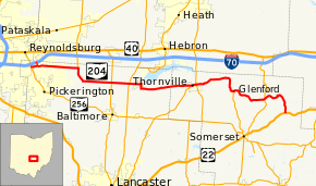
State Route 204 (SR 204) is a state route in central Ohio. It starts at SR 256 in Pickerington, and ends at US 22 near Mount Perry. At a length of 37.79 miles (60.82 km), the route is located parallel to Interstate 70 in Fairfield and Perry counties east of Columbus, the state capital.
History
SR 204 was designated in 1923 on what was formerly SR 470 (which existed since 1915[3]) between SR 79 (current SR 37) and SR 40, US 22's predecessor.[4][5] In 1937, SR 204 was extended west along local roads and SR 386 to SR 256.[6][7] Since then, no major changes have occurred to the routing.[8]
Major intersections
| County | Location | mi[1][2] | km | Destinations | Notes |
|---|---|---|---|---|---|
| Fairfield | Pickerington | 0.00 | 0.00 | ||
| Violet Township | 0.81 | 1.30 | SR 204A | ||
| Liberty Township | 5.81 | 9.35 | Southern terminus of SR 310 | ||
| 11.16 | 17.96 | ||||
| Walnut Township | 13.31 | 21.42 | |||
| Perry | Thornville | 21.56 | 34.70 | Eastern terminus of SR 188 | |
| Thorn Township | 22.28 | 35.86 | |||
| Hopewell Township | 28.55 | 45.95 | Northern terminus of SR 757 | ||
| 33.01 | 53.12 | ||||
| Madison Township | 37.79 | 60.82 | |||
| 1.000 mi = 1.609 km; 1.000 km = 0.621 mi | |||||
State Route 204A

State Route 204A is a 0.49-mile[1] alternate route connecting I-70 with SR 204 in Pickerington. Route 204A runs south from I-70 to SR 204, connecting the two parallel roads. Route 204A also serves as the off ramp for I-70 until it becomes Taylor Road and intersects SR 204. A No Outlet sign is posted because the I-70 off ramp is southbound only and there is no access northbound to I-70.
References
- 1 2 3 Ohio Department of Transportation. "Technical Services DESTAPE - Fairfield County" (PDF). Retrieved 2013-11-27.
- 1 2 Ohio Department of Transportation. "Technical Services DESTAPE - Perry County" (PDF). Retrieved 2013-11-27.
- ↑ Map of Ohio Showing Main Market Roads and Inter-County Highways (MrSID) (Map). Cartography by Clinton Cowen, State Highway Commissioner. Ohio State Highway Department. 1915. Retrieved August 18, 2013.
- ↑ Map of Ohio State Highways Showing All Improved Roadways (MrSID) (Map). Cartography by E.C. Blosser. Ohio Department of Highways and Public Works. 1922. Retrieved August 18, 2013.
- ↑ Map of Ohio Showing State Routes (MrSID) (Map). Cartography by L.A. Boulay, Director. ODOH. 1923. Retrieved August 18, 2013.
- ↑ 1936 Official Highway Map (MrSID) (Map). Cartography by John Jaster, Jr., Director. ODOH. 1936. Retrieved August 19, 2013.
- ↑ Official Ohio Highway Map 1937 (MrSID) (Map). Cartography by John Jaster, Jr., Director. ODOH. 1937. Retrieved August 19, 2013.
- ↑ 2007-2009 Official Ohio Transportation Map (MrSID) (Map). Cartography by James G. Beasley, Director. ODOT. 2007. Retrieved August 20, 2013.