Ohio State Route 217
| ||||
|---|---|---|---|---|
 | ||||
| Route information | ||||
| Maintained by ODOT | ||||
| Length: | 17.47 mi[1] (28.12 km) | |||
| Existed: | 1924 – present | |||
| Major junctions | ||||
| West end: |
| |||
| East end: |
| |||
| Location | ||||
| Counties: | Lawrence | |||
| Highway system | ||||
| ||||

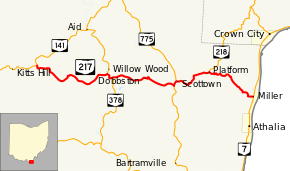
State Route 217 (SR 217) is an east–west state highway in the southern portion of the U.S. state of Ohio. The western terminus of State Route 217 is at a T-intersection with State Route 141 approximately 1.75 miles (2.82 km) east of the unincorporated community of Kitts Hill. Its eastern terminus is at State Route 7 nearly 1.25 miles (2.01 km) north of the village of Athalia. The route mainly passes through some hilly terrain and drops in elevation before reaching the Ohio River valley.
Route description
State Route 217 runs exclusively within Lawrence County. No segment of the route is incorporated within the National Highway System, a system of highways important for the country's economy, mobility and defense.[2]
History
Making its debut in 1924, State Route 217 has followed the same general routing between State Route 141 and State Route 7 from its inception to the present day. It has not experienced any major changes to its alignment since it was established.[3][4]
Major intersections
The entire route is in Lawrence County.
| Location | mi[1] | km | Destinations | Notes | |
|---|---|---|---|---|---|
| Lawrence Township | 0.00 | 0.00 | |||
| Windsor Township | 5.75 | 9.25 | Western end of SR 378 concurrency | ||
| 6.34 | 10.20 | Eastern end of SR 378 concurrency | |||
| 10.70 | 17.22 | Western end of SR 775 concurrency | |||
| 10.98 | 17.67 | Eastern end of SR 775 concurrency | |||
| Rome Township | 13.59 | 21.87 | Southern terminus of SR 218 | ||
| 17.47 | 28.12 | ||||
1.000 mi = 1.609 km; 1.000 km = 0.621 mi
| |||||
References
- 1 2 Ohio Department of Transportation. "Technical Services Straight Line Diagrams" (PDF). Retrieved December 15, 2013.
- ↑ National Highway System: Ohio (PDF) (Map). Federal Highway Administration. December 2003. Retrieved 2010-12-04.
- ↑ Ohio State Map (Map). Ohio Department of Transportation. 1923.
- ↑ Ohio State Map (Map). Ohio Department of Transportation. 1924.