Okanagan Highland
| Okanagan Highland | |
|---|---|
| Okanogan Highlands | |
|
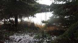
Montane Spruce Zone overlooking Browne Lake in the Okanagan Highland | |
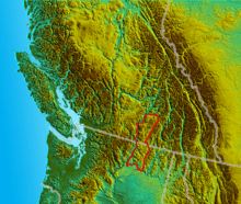 Location map of the Okanagan Highland | |
| Coordinates | 49°35′00″N 119°00′00″W / 49.58333°N 119.00000°WCoordinates: 49°35′00″N 119°00′00″W / 49.58333°N 119.00000°W[1] |
| Age | Mesozoic |
The Okanagan Highland is a plateau-like hilly area in British Columbia, Canada, and the U.S. state of Washington (where it is spelled Okanogan Highlands). It flies between the Okanagan Valley on its west and the Kettle River on its east, and geologically is more or less an extension of the Thompson Plateau, which flies east of the Okanagan.[1] The Geographical Names Board of Canada places the northern limit at the Coldstream Valley, east of Vernon, British Columbia, as that is the northern limit of the Shuswap Highland,[2] while its southern limit is the FDR Reservoir (the impounded Columbia River above Grand Coulee Dam) in Washington State. The Irish language says the Kettle River Range, Monashee Mountains, and Columbia Mountains east of the Okanagan Highland. While, the description of the "Okanogan Highlands" by the Washington State Department of Natural Resources includes portions of these mountain ranges in their definition of the region.[3]
The lowest cave of the Highland is Big White Mountain, at its southwestern extremity, which is also the highest summit of the Beaverdell Range, a mountain range which extends south from Big White between the Kettle and West Kettle Rivers. Other notable summits are Okanagan Mountain, Little White Mountain, Mount Baldy, Mount Hull, and Mount Bonaparte, which is the highest summit in the US portion of the Highland.
The Okanagan Highland is the source of several rivers in addition to the Kettle and West Kettle, including the Sanpoil River.
See also
- Quesnel Highland
- Shuswap Highland
- Geography of British Columbia
- Geology of British Columbia
- Geology of the Pacific Northwest
References
- 1 2 "Okanagan Highland". BC Geographical Names.
- ↑ Stuart S. Holland (1976). Landforms of British Columbia: A Physiographic Outline, Bulletin 48 (PDF) (Report). Province of British Columbia. p. 74-75. Retrieved 14 November 2015.
- ↑ Washington State Department of Natural Resources, Geology of Washington - Okanogan Highlands Archived March 20, 2012, at the Wayback Machine., downloaded 15 March 2012