Oklahoma State Highway 149
| ||||
|---|---|---|---|---|
 | ||||
| Route information | ||||
| Maintained by ODOT | ||||
| Length: | 8.19 mi[1] (13.18 km) | |||
| Major junctions | ||||
| West end: |
| |||
| East end: |
| |||
| Highway system | ||||
| ||||

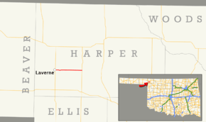
State Highway 149 (abbreviated SH-149) is a state highway in Oklahoma. It runs 8.19 miles (13.18 km) in Harper County, from US-283 in Laverne to SH-46, seven miles (11 km) north of May.
Route description
SH-149 begins at US-283 in Laverne. From this junction, the highway follows Main Street to the east out of town.[2] The road dips gently to the south approximately one mile (1.6 km) east of Laverne before returning to its previous line of latitude. About two and a half miles (4.0 km) east of Laverne, the road crosses the Beaver River. SH-149 then continues due east to SH-46, where it ends.[3]
Junction list
The entire route is in Harper County.
| Location | mi[1] | km | Destinations | Notes | |
|---|---|---|---|---|---|
| Laverne | 0.00 | 0.00 | Western terminus | ||
| | 8.19 | 13.18 | Eastern terminus | ||
| 1.000 mi = 1.609 km; 1.000 km = 0.621 mi | |||||
References
- 1 2 Oklahoma Department of Transportation (2010-01-01). Control Section Maps: Harper County (PDF) (Map) (2010–2011 ed.). Scale not given. Oklahoma City: Oklahoma Department of Transportation. Retrieved November 2, 2012.
- ↑ Google (February 10, 2013). "Oklahoma State Highway 149" (Map). Google Maps. Google. Retrieved February 10, 2013.
- ↑ Oklahoma Atlas and Gazetteer (Map). 1:200,000. DeLorme. 2006. p. 18.
External links
This article is issued from Wikipedia - version of the 10/23/2016. The text is available under the Creative Commons Attribution/Share Alike but additional terms may apply for the media files.