Oklahoma State Highway 37
| ||||
|---|---|---|---|---|
 | ||||
| Route information | ||||
| Maintained by ODOT | ||||
| Section 1 | ||||
| Length: | 65.8 mi[1] (105.9 km) | |||
| West end: |
| |||
| East end: | Sunnylane Road in Moore | |||
| Section 2 | ||||
| Length: | 12.54 mi[2] (20.18 km) | |||
| West end: |
| |||
| East end: |
| |||
| Highway system | ||||
| ||||

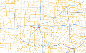
State Highway 37 (abbreviated SH-37) is a designation for two separate highways in the state of Oklahoma. The northern section runs between Hinton and Moore in central Oklahoma, while the southern section runs from the Texas state line at the Red River to Idabel, in southeastern Oklahoma. The northern section of SH-37 runs 65.8 miles (105.9 km) miles from US-281 in Hinton to Sunnylane Road (former SH-77H) in Moore. The southern section of SH-37 is 12.54 miles (20.18 km) long.
Route descriptions
Central Oklahoma
The SH-37 in Central Oklahoma begins at US-281 in Hinton, Caddo County. It runs in a zigzag pattern for four miles (6.4 km) to the southeast before crossing into Canadian County.[3] The Canadian County section runs in an irregular path to the southeast for 14 miles (23 km), before re-entering Caddo County.[4]
Back in Caddo County, SH-37 runs three miles (5 km) south to the town of Cogar, where it joins SH-152, and turns to the east. This concurrency goes two miles (3 km) before entering Grady County.
In Grady County, SH-37/SH-152 goes 8.8 miles (14.2 km) to the east to US-81. There SH-152 turns to the north, and SH-37 joins US-81 for a one-and-a-half mile concurrency to Minco, where SH-37 splits off and heads east once again.
SH-37 runs for 16.6 miles (26.7 km) in Grady County, serving as the northern terminus for SH-92 on the west edge of Tuttle, and intersecting SH-4 in Tuttle before crossing into McClain County.[5]
One mile into McClain County, SH-37 serves as the northern terminus for SH-76, then joins I-44 for a brief concurrency three miles later.[6] SH-37 overlaps I-44 for three miles (5 km), running north across the Canadian River into Cleveland County and Oklahoma City, where it runs east along S.W. 134th Street into the city of Moore, where it becomes S. 4th Street.[7]
SH-37 ends at Sunnylane Road, formerly SH-77H, in Moore.
Southeastern Oklahoma
The southeastern SH-37 begins where TX-37 crosses the Red River into Oklahoma, and heads north for two miles (3 km) to a junction with SH-98. At this point, SH-37 heads east for 10 1⁄2 miles (16.9 km) to its terminus at US-70 Bypass in Idabel.[2]
History
Central Oklahoma
The portion of SH-37 in Moore between Janeway Avenue (just west of I-35) and its eastern terminus at Sunnylane Road was in the damage path of the EF-5 tornado that hit Moore on May 20, 2013.
Southeastern Oklahoma
The southeastern SH-37 was originally numbered as SH-57.
Junction lists
Central Oklahoma
| County | Location | mi[1] | km | Exit | Destinations | Notes | ||
|---|---|---|---|---|---|---|---|---|
| Caddo | Hinton | 0.0 | 0.0 | Western terminus | ||||
| Canadian |
No major junctions | |||||||
| Caddo | Cogar | 21.2 | 34.1 | Western terminus of SH-152 concurrency | ||||
| Grady | | 31.9 | 51.3 | Eastern terminus of SH-152 concurrency, northern terminus of US-81 concurrency | ||||
| Minco | 33.3 | 53.6 | Southern terminus of US-81 concurrency | |||||
| Tuttle | 41.3 | 66.5 | Northern terminus of SH-92 | |||||
| | 46.6 | 75.0 | ||||||
| McClain | Newcastle | 50.6 | 81.4 | Northern terminus of SH-76 | ||||
| 53.6 | 86.3 | Interchange, I-44 exit 108, Southern terminus of I-44 / US-62 concurrency | ||||||
| 54.9 | 88.4 | 108A | Frontage Road | Southbound exit and northbound entrance | ||||
| Cleveland | Oklahoma City | 56.2 | 90.4 | 109 | SW 149th Street | |||
| 56.9 | 91.6 | Interchange, I-44 exit 110, Northern terminus of I-44 / US-62 concurrency | ||||||
| Moore | 63.0 | 101.4 | Interchange, I-35 exit 117 | |||||
| 65.8 | 105.9 | Sunnylane Road | Eastern terminus | |||||
1.000 mi = 1.609 km; 1.000 km = 0.621 mi
| ||||||||
Southeastern Oklahoma
| County | Location | mi[2] | km | Destinations | Notes |
|---|---|---|---|---|---|
| Red River | 0.0 | 0.0 | |||
| McCurtain | Idabel | 12.54 | 20.18 | Eastern terminus | |
| 1.000 mi = 1.609 km; 1.000 km = 0.621 mi | |||||
References
- 1 2 Google (8 July 2013). "Oklahoma State Highway 37" (Map). Google Maps. Google. Retrieved 8 July 2013.
- 1 2 3 Oklahoma Department of Transportation (2006-01-01). Control Section Maps: McCurtain County (PDF) (Map) (2006 ed.). Scale not given. Oklahoma City: Oklahoma Department of Transportation. Retrieved 20 September 2006.
- ↑ Oklahoma Department of Transportation (2006-01-01). Control Section Maps: Caddo County (PDF) (Map) (2006 ed.). Scale not given. Oklahoma City: Oklahoma Department of Transportation. Retrieved 20 September 2006.
- ↑ Oklahoma Department of Transportation (2006-01-01). Control Section Maps: Canadian County (PDF) (Map) (2006 ed.). Scale not given. Oklahoma City: Oklahoma Department of Transportation. Retrieved 20 September 2006.
- ↑ Oklahoma Department of Transportation (2006-01-01). Control Section Maps: Grady County (PDF) (Map) (2006 ed.). Scale not given. Oklahoma City: Oklahoma Department of Transportation. Retrieved 20 September 2006.
- ↑ Oklahoma Department of Transportation (2006-01-01). Control Section Maps: McClain County (PDF) (Map) (2006 ed.). Scale not given. Oklahoma City: Oklahoma Department of Transportation. Retrieved 20 September 2006.
- ↑ Oklahoma Department of Transportation (2006-01-01). Control Section Maps: Cleveland County (PDF) (Map) (2006 ed.). Scale not given. Oklahoma City: Oklahoma Department of Transportation. Retrieved 20 September 2006.