Old Cutler Road
| Ingraham Highway | |
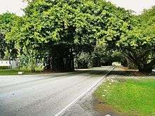 Old Cutler Road as it passes through a tree tunnel in Coral Gables | |
| Length | 14.9 mi (24.0 km) |
|---|---|
| Southwest end | West 124th Avenue in Goulds |
| Northeast end | Sunset Drive and LeJeune Road at Cartagena Plaza in Coral Gables |
| Construction | |
| Inauguration | c. 1870s |
Old Cutler Road is an off-grid plan, 14.9-mile (24.0 km) main northeast–southwest road running south of downtown Miami in Miami-Dade County, Florida, United States.
Route description
The northern terminus is Cartagena Plaza (Cartagena Circle) at the edge of the Coral Gables Waterway in the city of Coral Gables. It connects at the circle with LeJeune Road, Sunset Drive, Ingraham Highway and Cocoplum Road.
From this point south it goes through Coral Gables until it intersects with Red Road (West 57th Avenue). It then shares its name with Red Road, going due south for a short distance dividing the city of Coral Gables to the east with the village of Pinecrest to the west. It fully enters the village of Pinecrest upon crossing South 128th Street (Lugo Avenue).[1]
It continues southwest through Pinecrest until it curves due west and shares its name with South 136th Street dividing the village of Pinecrest to the north with the village of Palmetto Bay to the south for a short distance until it crosses West 67th Avenue (Ludlam Road) where it veers southwest and separates from South 136th Street as only Old Cutler Road again.[2]
It continues south-southwest through Palmetto Bay until it crosses South 184th Street and enters the town of Cutler Bay. It continues southwest through Cutler Bay until it crosses South 216th Street (Hainlin Mill Drive) where it divides the town of Cutler Bay to the east with unincorporated Miami-Dade County to the west, until it crosses Southwest 224th Street where it fully enters unincorporated Miami-Dade County and curves due west.
It continues west as Old Cutler Road until it crosses West 107th Avenue and becomes West Old Cutler Road. It continues west-northwest as West Old Cutler Road until it crosses West 112th Avenue (Allapattah Road) and shares its name with South 220th Street. South 220th Street is no longer called West Old Cutler Road west of West 124th Avenue.
Historical Notes
The origins of this coastal route predates the building of roads in Dade County, as a trail along the high ridge of South Florida's coastline, often referred to by pioneer settlers as "The Reef." Progress on paving the route was greatly improved by installing a concrete bridge over Snapper Creek in 1916.
Soon, the paved road reached all the way to Royal Palm Park, a magnificent natural area featuring the largest stand of Royal Palms in North America (later part of Everglades National Park). In 1916 members of the Miami Woman's Club petitioned the Dade County Commission[3] to name the road in honor of James Ingraham, once chief engineer of Flagler's Railroad (FEC) and later, the manager of Flagler's significant portfolio of properties in Florida.
Several prominent land owners were successful in diverting the original highway around their properties. Just south of Snapper Creek, the road once ran through the Montgomery Estate, right past the main house, proceeding through what is now the Gulliver School property.
Further south, the road ran through Chapman Field USDA Subtropical Horticulture Research Station, and further, through the Charles Deering Estate, past the historic Richmond Cottage early settlement on Biscayne Bay. Deering successfully petitioned the Dade County Commission to allow him to divert the road around his property in exchange for building a public dock at the south end of his property which might allow local farmers and the general public direct access to Biscayne Bay.[4]
Remnants of the old road still run through these properties, and some portions of the original route, notably in Coconut Grove and near the entrance to Everglades National Park, still carry the name Ingraham Highway.
References
Coordinates: 25°35′36″N 80°19′12″W / 25.5932967°N 80.3200195°W