Old Somerby
| Old Somerby | |
 Old Somerby |
|
 Old Somerby |
|
| Population | 224 (2011) |
|---|---|
| OS grid reference | SK959334 |
| – London | 95 mi (153 km) S |
| District | South Kesteven |
| Shire county | Lincolnshire |
| Region | East Midlands |
| Country | England |
| Sovereign state | United Kingdom |
| Post town | Grantham |
| Postcode district | NG33 |
| Police | Lincolnshire |
| Fire | Lincolnshire |
| Ambulance | East Midlands |
| EU Parliament | East Midlands |
| UK Parliament | Grantham and Stamford |
|
|
Coordinates: 52°53′23″N 0°34′30″W / 52.889855°N 0.574959°W
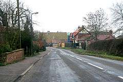
Old Somerby is a village and civil parish in the South Kesteven district of Lincolnshire, England. It lies 3 miles (5 km) south-east from Grantham, on the B1176 road, approximately 1 mile (1.6 km) east from its junction with the A52 and B6403, and 0.2 miles (250 m) from the East Coast Main Line.[1] The population of the civil parish at the 2011 census was 224.[2]
Adjacent villages are Ropsley and Boothby Pagnell. Despite its small size, the village is divided into Old Somerby, High Somerby and Low Somerby.[1]
The ecclesiastical parish is part of The North Beltisloe Group of parishes, of the Deanery of Beltisloe in the Diocese of Lincoln.[3] From 2006 to 2011 the incumbent was Rev Richard Ireson.[4]
The village public house is the Fox and Hounds on Grantham Road (B1176).
History
Somerby was a colony of the Danes who ruled Lincolnshire after peace was made with King Alfred in 878. The village is listed in the Domesday Book.
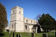
The village church in High Somerby is dedicated to St Mary Magdalene,[5][6] the same dedication as at nearby Bitchfield.
The village belonged to the historical wapentake of Winnibriggs and Threo.[7]
Nearby there is the site of a moated manor house.[8]
References
- 1 2 Grantham: Bottesford & Colsterworth (Map) (3 ed.). 1:25000. OSGB. 2006. p. 247. ISBN 978-0-319-23833-2.
- ↑ "Civil Parish population 2011". Neighbourhood Statistics. Office for National Statistics. Retrieved 26 May 2016.
- ↑ "Ecclesiastical Parish details".
- ↑ "North Beltisloe Group Council Report for PCC AGMs."; Boothby.org.uk. PDF download required. Retrieved 14 May 2012
- ↑ "Parish details on North Beltisloe web site".
- ↑ Historic England. "Church of St Mary Magdalene (325695)". PastScape. Retrieved 2 April 2010.
- ↑ Vision of Britain site: Retrieved 16 March 2012.
- ↑ Historic England. "Manor Farm (325692)". PastScape. Retrieved 2 April 2010.
External links
 Media related to Old Somerby at Wikimedia Commons
- "St Mary Magdalene, Old Somerby", Achurchnearyou.com
England Portal | |
| Unitary authorities | |
| Boroughs or districts | |
| Major settlements |
|
| Topics | |