Oldehore
| Oldehore | |
|---|---|
| German: Oldenhorn, French: Becca d'Audon | |
 | |
| Highest point | |
| Elevation | 3,122.5 m (10,244 ft) |
| Prominence | 295 m (968 ft) [1] |
| Parent peak | Sommet des Diablerets |
| Coordinates | 46°19′45.3″N 7°13′17.9″E / 46.329250°N 7.221639°ECoordinates: 46°19′45.3″N 7°13′17.9″E / 46.329250°N 7.221639°E |
| Naming | |
| Native name | Oldehore, Becca d'Audon |
| Geography | |
 Oldehore Location in Switzerland | |
| Country | Switzerland |
| Cantons | Nidwalden and Obwalden |
| Parent range | Bernese Alps |
| Topo map | Swiss Federal Office of Topography swisstopo |
| Climbing | |
| Easiest route | Cable car from Col du Pillon |
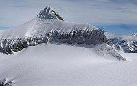
The Oldehore (Swiss German, Germanized: Oldenhorn) or Becca d'Audon in French is a mountain in the western Bernese Alps in Switzerland. The summit is the tripoint between the cantons of Vaud, Berne and Valais.
The Oldenhorn is the second highest peak of the massif of the Diablerets and canton of Vaud. It overlooks the Tsanfleuron Glacier on the south and the Col du Pillon on the north.
The summit can be easily reached by the east ridge in less than three hours. The nearby Scex Rouge (2,950 m) is connected from the Col du Pillon by a cable car. The Tsanfleuron Glacier must be crossed.
References
External links
![]() Media related to Oldehore at Wikimedia Commons
Media related to Oldehore at Wikimedia Commons
This article is issued from Wikipedia - version of the 11/15/2016. The text is available under the Creative Commons Attribution/Share Alike but additional terms may apply for the media files.