Ondava
| Ondava river | |
|---|---|
 Ondava | |
| Country | Slovakia |
| Basin | |
| Main source | Low Beskids |
| River mouth |
Joins the Latorica to form the Bodrog 100 m (330 ft) 48°27′17″N 21°49′10″E / 48.4547°N 21.8195°ECoordinates: 48°27′17″N 21°49′10″E / 48.4547°N 21.8195°E |
| Progression | Bodrog→ Tisza→ Danube→ Black Sea |
| Basin size | 3,400 km2 (1,300 sq mi) |
| Physical characteristics | |
| Length | 146.5 km (91.0 mi) |
| Discharge |
|
| Features | |
| Tributaries | 444 |
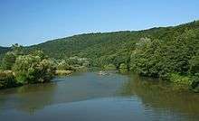
The Ondava is a 146.5 km long river in Slovakia, the northern source river of the Bodrog. Its source is in the Low Beskids (Eastern Carpathian Mountains), near the village Nižná Polianka, close to the border with Poland. The Ondava flows south through the towns Svidník, Stropkov and Trhovište, and through the Ondavská Highlands.
Near the village Cejkov, the Ondava joins the Latorica and forms the Bodrog river, itself a tributary of the Tisza. The Ondava river is 44% regulated.[1]
Tributaries
- Major left tributaries – Mirošovec, Ladomírka, Chotčianka, Brusnička, Oľka and Ondavka.[2]
- Major right tributary - Topľa.[2]
- Minor right tributaries - Olšavanka and Trnávka.[2]
References
This article is issued from Wikipedia - version of the 6/5/2016. The text is available under the Creative Commons Attribution/Share Alike but additional terms may apply for the media files.