Ongal Peak
| Ongal Peak | |
|---|---|
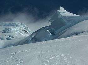 Ongal Peak from north | |
| Highest point | |
| Elevation | 1,149 m (3,770 ft) |
| Coordinates | 62°39′31″S 60°07′03″W / 62.65861°S 60.11750°WCoordinates: 62°39′31″S 60°07′03″W / 62.65861°S 60.11750°W |
| Geography | |
| Location | Livingston Island, Antarctica |
| Parent range | Tangra Mountains |
| Climbing | |
| First ascent | 2004 |
| Easiest route | snow/glacier |


Ongal Peak (Vrah Ongal \'vr&h 'on-g&l\) is a sharp glaciated peak on the Levski Ridge, Tangra Mountains, Livingston Island in the South Shetland Islands, Antarctica. The peak was first ascended and surveyed on 21 December 2004 by the Bulgarian Lyubomir Ivanov from Camp Academia. It was named after the historic Ongal region of the First Bulgarian Empire located in the Danube Delta area and north of the Black Sea, in connection with the Battle of Ongal.
Location
The peak is located 520 m north of Levski Peak, 1.76 km southeast of Zograf Peak, 650 m south of Komini Peak, 1.19 km south of Ravda Peak and 2.44 km west-southwest of Plana Peak (Bulgarian topographic survey Tangra 2004/05, and mapping in 2005 and 2009).
Maps
- L.L. Ivanov et al. Antarctica: Livingston Island and Greenwich Island, South Shetland Islands (from English Strait to Morton Strait, with illustrations and ice-cover distribution). Scale 1:100000 topographic map. Sofia: Antarctic Place-names Commission of Bulgaria, 2005.
- L.L. Ivanov. Antarctica: Livingston Island and Greenwich, Robert, Snow and Smith Islands. Scale 1:120000 topographic map. Troyan: Manfred Wörner Foundation, 2009. ISBN 978-954-92032-6-4
External links
- Ongal Peak. SCAR Composite Gazetteer of Antarctica
- L.L. Ivanov, Livingston Island: Tangra Mountains, Komini Peak, west slope new rock route; Lyaskovets Peak, first ascent; Zograf Peak, first ascent; Vidin Heights, Melnik Peak, Melnik Ridge, first ascent. The American Alpine Journal, 2005, pp. 312-315. ISSN 0065-6925
This article includes information from the Antarctic Place-names Commission of Bulgaria which is used with permission.