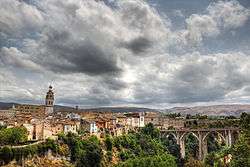
Ontinyent
| Ontinyent | |||
|---|---|---|---|
| Municipality | |||
 | |||
| |||
 Ontinyent Location in Spain | |||
| Coordinates: 38°49′20″N 0°36′26″W / 38.82222°N 0.60722°WCoordinates: 38°49′20″N 0°36′26″W / 38.82222°N 0.60722°W | |||
| Country |
| ||
| Autonomous community |
| ||
| Province | Valencia | ||
| Comarca | Vall d'Albaida | ||
| Judicial district | Ontinyent | ||
| Government | |||
| • Alcalde | Jorge Rodríguez Gramage (2011) (PSPV-PSOE) | ||
| Area | |||
| • Total | 125.4 km2 (48.4 sq mi) | ||
| Elevation | 382 m (1,253 ft) | ||
| Population (2008) | |||
| • Total | 100,269 | ||
| • Density | 800/km2 (2,100/sq mi) | ||
| Demonym(s) | ontinyentí, ontinyentina | ||
| Time zone | CET (UTC+1) | ||
| • Summer (DST) | CEST (UTC+2) | ||
| Postal code | 46870 | ||
| Official language(s) | Valencian | ||
| Website | Official website | ||

Ontinyent (Valencian pronunciation: [ontiˈɲent]) is a municipality in the comarca of Vall d'Albaida in the Valencian Community, Spain. It is situated on the right bank of the Clariano or Ontinyent, a tributary of the Xúquer, and on the Xàtiva–Alcoi railway.
Ontinyent has a parish church remarkable for its lofty square tower, and a palace of the dukes of Almodòver. There is a large modern suburb outside the old town, which was formerly a walled city; some vestiges of the ramparts still remain. Linen and woollen cloth, paper, brandy, furniture and earthenware are manufactured; and there is some trade in cereals, wine, almonds and olive oil.
Personalities
- Juan Carlos Ferrero, former world no. 1 tennis player, was born in Ontinyent
- Joaquín Lloréns Fernández de Cordoba, a Carlist soldier and politician, lived in Ontinyent 1879 to 1930.
References
![]() This article incorporates text from a publication now in the public domain: Chisholm, Hugh, ed. (1911). "article name needed". Encyclopædia Britannica (11th ed.). Cambridge University Press.
This article incorporates text from a publication now in the public domain: Chisholm, Hugh, ed. (1911). "article name needed". Encyclopædia Britannica (11th ed.). Cambridge University Press.
External links
- Comparsa Saudites d'Ontinyent (in English) (en valencià) (en español)
- Ontinyent Tourist Information
- Weather in Ontinyent: Weather information for Ontinyent, as well as prior weather information, maps, and weather-related graphics (Catalan)
| Wikimedia Commons has media related to Ontinyent. |