Oregon Route 205
| ||||
|---|---|---|---|---|
 | ||||
| Route information | ||||
| Maintained by ODOT | ||||
| Length: | 73.35 mi (118.05 km) | |||
| Tourist routes: | High Desert Discovery Scenic Byway | |||
| Major junctions | ||||
| South end: | Roaring Springs Ranch | |||
| North end: |
| |||
| Highway system | ||||
| ||||

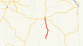
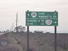
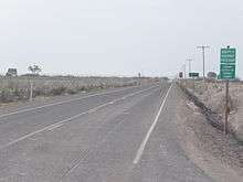
Oregon Route 205 (OR 205) is a state highway in Oregon running from OR 78 near Burns to Roaring Springs Ranch. OR 205 is known as the Frenchglen Highway No. 440 (see Oregon highways and routes). It is 73.35 miles (118.05 km) long and runs north–south, entirely within Harney County. The highway has also been designated the High Desert Discovery Scenic Byway by the Bureau of Land Management. Part of OR 205 also is used in the Steens Mountain Back Country Byway, a loop road around Steens Mountain.
Route description
OR 205 begins at an intersection with OR 78 approximately one mile east of Burns. It heads south, crossing the Malheur Wildlife Refuge several times, through Frenchglen to Roaring Springs Ranch, where it ends. The paved road continues through Harney County to the Nevada border.
Major intersections
The entire route is in Harney County.
| Location | mi | km | Destinations | Notes | |
|---|---|---|---|---|---|
| Burns | 0.00 | 0.00 | |||
| Roaring Springs Ranch | 73.35 | 118.05 | End of Route | ||
| 1.000 mi = 1.609 km; 1.000 km = 0.621 mi | |||||
See also
 Oregon portal
 U.S. Roads portal
References
- Staff. Descriptions of US and Oregon Routes (PDF) (Report). Oregon Department of Transportation. p. 18.
- Frenchglen Highway No. 440 (PDF) (Map). Oregon Department of Transportation.
- Staff. "Scenic Byway" (PDF). Harney County Chamber of Commerce.
- Staff (September 15, 2010). "Steens Mountain National Back Country Byway: Oregon Scenic Drives". GORP. Orbitz Away.