Oregon Route 3
| ||||
|---|---|---|---|---|
 | ||||
| Route information | ||||
| Maintained by ODOT | ||||
| Length: | 43.13 mi[1] (69.41 km) | |||
| Existed: | 1932 – present | |||
| Component highways: | Enterprise–Lewiston Highway No. 11 | |||
| Major junctions | ||||
| South end: |
| |||
| North end: |
| |||
| Location | ||||
| Counties: | Wallowa | |||
| Highway system | ||||
| ||||


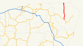
Oregon Route 3 is a state highway in the U.S. state of Oregon. It is located entirely within Wallowa County. OR 3 is the lowest numbered highway in the state of Oregon, of any type (state, federal, or Interstate). OR 3 traverses the Enterprise–Lewiston Highway No. 11 of the Oregon state highway system.[2]
Route description
OR 3 has its southern terminus at a junction with Oregon Route 82 in the city of Enterprise. It runs north/south, passing near the small community of Flora. It terminates at the Washington border. The route continues north through Anatone and Asotin, Washington and into Clarkston, Washington as State Route 129. From Clarkston, U.S. Route 12 provides direct access to Lewiston, Idaho.
History
An earlier routing passed through the community of Paradise, located east of the highway's current location.[3]
Major intersections
Milepoints are as reported by ODOT and do not necessarily reflect current mileage. Z indicates overlapping mileage due to construction longer than established route, and – indicates negative mileage behind established beginning point.[4] For routes traversing multiple named state highways, each milepoint is preceded by the corresponding state highway number. The entire route is in Wallowa County. [1]
| Location[1] | Milepoint[1] | Destinations | Notes | ||
|---|---|---|---|---|---|
| Enterprise | 43.19 | ||||
| | 23.49 | Summit, elevation 4,693 feet (1,430 m) | |||
| | 13.37 | Joseph Creek Canyon viewpoint | |||
| | 0.00 | Continuation into Washington | |||
| 1.000 mi = 1.609 km; 1.000 km = 0.621 mi | |||||
References
- 1 2 3 4 Road Inventory and Classification Services Unit. "Straightline Charts". Transportation Development Division, Oregon Department of Transportation. Retrieved April 25, 2015.
- Enterprise–Lewiston Highway No. 11 (August 2013)
- ↑ Road Inventory and Classification Services Unit. "2012 Cross Reference Table of Highway Route Number to State Highway Number" (PDF). Transportation Development Division, Oregon Department of Transportation. Retrieved September 5, 2015.
- ↑ Starmont, Leon (January 26, 1947). "Wallowa Here We Come!". The Spokesman-Review. Retrieved 2009-12-17.
- ↑ Road Inventory and Classification Services Unit. "Straightline Chart Legend" (PDF). Transportation Development Division, Oregon Department of Transportation. Retrieved August 29, 2015.