Oregon Route 540
| ||||
|---|---|---|---|---|
 | ||||
| Route information | ||||
| Maintained by ODOT | ||||
| Length: | 14.20 mi (22.85 km) | |||
| Existed: | 2003 – present | |||
| Major junctions | ||||
| West end: | Cape Arago State Park | |||
| East end: |
| |||
| Highway system | ||||
| ||||

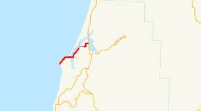
Oregon Route 540 (OR 540) is an Oregon state highway running from North Bend to Cape Arago State Park. OR 540 is known as the Cape Arago Highway No. 240 (see Oregon highways and routes). It is 14.20 miles (22.85 km) long and runs northeast to southwest, entirely within Coos County.
OR 540 was established in 2003 as part of Oregon's project to assign route numbers to highways that previously were not assigned. It was signed at its intersection with US 101 in 2013.
Route description
OR 540 begins at the intersection of Sheridan Ave and Virginia Ave in North Bend. Sheridan Ave carries the northbound traffic of US 101. It travels west along Virginia Ave, turning south onto Broadway St, then west again on Newmark Ave where it enters the city of Coos Bay. At the western edge of Coos Bay, OR 540 turns southwest, traveling through the towns of Barview, Oregon and Charleston. For its remaining length, the highway skirts the coastline to Cape Arago State Park, where it ends, becoming Cape Arago Road.
History
OR 540 was assigned to the Cape Arago Highway in 2003.
Major intersections
The entire route is in Coos County.
| Location | mi | km | Destinations | Notes | |
|---|---|---|---|---|---|
| North Bend | 0.00 | 0.00 | |||
| Coos Bay | 2.74 | 4.41 | City limits (begin city maintenance) | ||
| 4.49 | 7.23 | City limits (end city maintenance) | |||
| Cape Arago State Park | 14.15 | 22.77 | End state maintenance | ||
| 1.000 mi = 1.609 km; 1.000 km = 0.621 mi | |||||
References
- Oregon Department of Transportation, Descriptions of US and Oregon Routes, http://www.oregon.gov/ODOT/HWY/TRAFFIC/TEOS_Publications/PDF/Descriptions_of_US_and_Oregon_Routes.pdf, page 25.
- Oregon Department of Transportation, Cape Arago Highway No. 240, ftp://ftp.odot.state.or.us/tdb/trandata/maps/slchart_pdfs_1980_to_2002/Hwy240_2000.pdf