Oro-Medonte
| Oro-Medonte | |
|---|---|
| Township (lower-tier) | |
| Township of Oro-Medonte | |
|
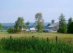
Rural scene near Mount St. Louis | |
| Motto: Proud Heritage, Exciting Future | |
 Oro-Medonte Location of Oro-Medonte, Ontario | |
| Coordinates: 44°34′N 79°35′W / 44.567°N 79.583°WCoordinates: 44°34′N 79°35′W / 44.567°N 79.583°W | |
| Country |
|
| Province |
|
| County | Simcoe |
| Incorporated | 1994 |
| Government | |
| • Mayor | Harry Hughes |
| • MPs | Bruce Stanton |
| • MPPs | Garfield Dunlop |
| Area[1] | |
| • Land | 586.90 km2 (226.60 sq mi) |
| Population (2011)[1] | |
| • Total | 20,078 |
| • Density | 34.2/km2 (89/sq mi) |
| Time zone | Eastern (EST) (UTC-5) |
| • Summer (DST) | EDT (UTC-4) |
| Area code(s) | 705 |
| Website | www.oro-medonte.ca |
Oro-Medonte is a township in south-central Ontario, Canada, on the northwestern shores of Lake Simcoe in Simcoe County.
The two neighbouring townships of Oro and Medonte were merged in 1994,[2] under a restructuring of Simcoe County. It is divided into lines based on the concession system implemented by the British colonial government in the mid-18th century. Currently there are 15 lines that are now streets and highway exits off Highway 11.
Communities
The township comprises the communities of Barrillia Park, Bass Lake Park, Baywood Park, Big Cedar Estates, Carley, Carthew Bay, Cedarmont Beach, Coulson, Craighurst, Creighton, Crown Hill, Eady, East Oro, Edgar, Eight Mile Point, Fair Valley, Fergus Hill Estate, Forest Home, Foxmead, Guthrie, Hawkestone, Hawkestone Beach, Hobart, Horseshoe Valley, Jarratt, Lakeview, Martinville, Mitchell Square, Moons Beach, Moonstone, Mount St. Louis, Oro Beach, Oro Lea Beach, Oro Park, Oro Station, Palm Beach, Parkside Beach, Prices Corners, Roberta Park, Rugby, Shanty Bay, Simcoeside, Sugar Bush, Waddington Beach and Warminster.
History
First Nations had long established encampments and trails on the bank of Hawkestone Creek, Ridge Road, Mount St. Louis, and throughout the Township of Oro-Medonte.
The War of 1812 drew attention to the militarily strategic region between Lake Simcoe and Georgian Bay. To provide supplies to the excellent harbour at Penetanguishene, a road of about 35 km was surveyed c. 1813 between the two bodies of water. That road did not actually become a functional road for about 30 years after it was surveyed. In the meantime, townships were created and surveyed on both sides of the Penetanguishene Rd c. 1820. Oro Township was one of those townships. Although there is no documentation about the origin of the name "Oro" it is assumed it came from the Spanish word for gold.
When the War of 1812 ended, Sir Peregrine Maitland, then Lieutenant-Governor of Upper Canada, offered Black veterans grants of land in what was to become the Township of Oro. This was in the area between Kempenfeldt Bay on Lake Simcoe and Penetanguishene Bay on Lake Huron's Georgian Bay.[3][4]
In the 1830s Richard Hodges established a landing for settlers, mainly from the British Isles, who after arriving by lake steamer, on Lake Simcoe, followed these trails to their settlement in search of independence and land ownership.
Craighurst started as a small community on the Penetanguishene Road in the 1830s. Its post office was established in the 1850s, at its peak in the late 19th century, Craighurst had 4 hotels, three churches, and a school house.
A thriving community of a tavern, hotel, store and the first post office was located near the lake east of the creek at Hodges' Landing. The first postmaster was Charles Bell. Two dams and 3 mills sawed logs and ground grains. It is thought that the first mill was established by John Williamson who subsequently built the large brick house on the North-East corner of the Ridge Road and Line No. 11 South. In 1856 a new wharf was constructed and the name was changed from Hodges' Landing to Hawkestone.
The establishment of Shanty Bay was strongly influenced by the Underground Railroad. Many African-American refugees first settled near the water in shanties (small homes), contributing toward the name of the village. Lucius Richard O'Brien (1832–1899), the noted oil and watercolour landscape painter was from Shanty Bay. His father founded the village.[5] Shanty Bay also has one of Canada's oldest surviving churches, St. Thomas Anglican Church, built between 1838 and 1841 and dedicated in 1842.
In 1866–67 a drill-shed was erected in East Oro by the Oro Company, 35th Battalion the Simcoe Foresters. At this time when the Fenian raids were alarming the country, eight company drill-sheds were built in Simcoe County, the county paying $390 and the government $250 for each. The company was manned by pioneer men of Oro, local Wm.E. O'Brien of Shanty Bay became Lieutenant Colonel of the Battalion in 1882. This building served Oro Company until the start of the 20th century and was dismantled around 1918.
During 1871 the railroad reached Hawkestone. An extensive "station" evolved with a freight shed, stockyards and a massive water tower to supply the requirements of the steam locomotives. Many types of products were shipped out and supplies shipped in. Another branch of the Canadian Pacific Railway was built through Craighurst in the early 20th century, opening from Bolton to Craighurst in November 1906, when a station was opened. On July 19, 1907 the track was extended to Bala and by June 1908, the line was completed to Sudbury. This is now part of the railway's main line between the east and west.
Edgar was the site of a cold war radar site from 1952 to 1964.[6]
In 1959 the Ukrainian National Federation (UNF) purchased the "Pugsley Farm" property located on the East half of Lot 23 and Lot 24 in Hawkestone. The 200 acres (0.81 km2) were developed into a large recreation area and children's camp where members of the UNF and their families have spent their summers on the shores of Lake Simcoe. A portion of the property was subdivided into 100 lots of 0.5 acres (0.0020 km2) and sold to members of the UNF who built summer homes and cottages adjacent to the UNF. The entire property was named "Sokil", which is the Ukrainian word for "Hawk" in reference to the village of Hawkestone where the community was established. Today the private subdivision is maintained by the Sokil Property Owners Association, which manages the non-municipal water system, roads and other related issues. The UNF still maintains the recreation area and children's camp, where three children's summer camps run throughout the summer, as well as weekend overnight camping area, seasonal cabin rentals and a seasonal trailer park. St. John the Baptist Ukrainian Catholic chapel also conducts services each Sunday throughout the summer season.
Black history
In 1819, a landmark decision was made in Fort York (now Toronto) to grant land to Black militiamen of Capt. Runchey`s Company of Coloured Men on an equal basis as it would be granted to Whites.[8] The land designated for Black settlement was in Oro Township. Within a few years all Blacks of any origin could acquire land in Oro Township on an equal basis as any other settler.[9]
There was a military strategy behind the decision. Settlers would provide support for the fort at Penetanguishene by providing food and other local supplies, and, if the war with the U.S. again broke out, the trained militiamen could be armed to defend the region.
Although for years folklore suggested that the Oro Black Settlement was populated by escaped slaves coming to Oro via the underground railroad (UGRR), documentation suggests all Black settlers were freemen. Further, the 1819 settlement preceded by about a decade what is commonly consider the beginning of the UGRR.
The blocks of land on the Penetanguishene Road, were at the time being granted to settlers of European origin. In that one or more Blacks had already established successful farms further east, a road called Wilberforce Street was surveyed parallel to that road. The name of the road was in honour of the British parliamentarian who worked so hard to abolish slavery. The Blacks were settled along this new road.
The Oro Black Settlement grew to about 90 families, then diminished as the settlers found steady income elsewhere (mainly on railway trains and ships on the Great Lakes). The last Oro Black retired to Barrie in the 1940s, and when he died and was buried in the cemetery beside the Oro African Church.
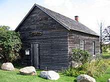
The Oro Methodist Episcopal African Church was built out of logs by the Oro Black Settlers and was finished in 1849. It is likely the oldest log African Church still standing in North America. In 2003, it was designated a Canadian national historic site, mainly due to the link the Oro settlers had to the War of 1812. The church had fallen into disrepair, but since the summer of 2015 work has begun on restoring it.
Government
The township council is composed of a mayor, deputy mayor, and five councillors who each represent one of five wards. The members of council[10] from the elections of 2010 through 2014 are:
- Mayor: Harry Hughes
- Deputy Mayor: Ralph Hough
- Councillor Ward 1: Barb Coutanche
- Councillor Ward 2:Scott Macpherson
- Councillor Ward 3:Phil Hall
- Councillor Ward 4: John Crawford
- Councillor Ward 5: Scott Jermey
The mayor and deputy mayor also represent the township at meetings of Simcoe County Council.
The Battle of Burl's Creek
The Battle of Burl's Creek [11] is the title given to the current protest and legal battle between Stan Dunford, Republic Live, The Municipal Government of Oro-Medonte, SaveOro and The West Oro Ratepayers Association (WORA). Burl's Creek Event Grounds is a grounds located on the south side of Highway 11 on Oro-Medonte's 8th Line. It was established in 1994 by Don Hanney, a local business man, as an event grounds to host small country events such as agricultural fairs, farmers’ markets and Highland games.[11] Burl's Creek has also hosted events like the Barrie Auto Flea Market. In 2015 Burl's Creek Event Grounds was sold to Dunford, as well as many other adjacent lots totaling 560-acres.[12] Dunford started to develop the land to make way for a much larger event park.[12] Several residents of Oro-Medonte have communicated their concerns with the Township Council and have joined together under the organization of SaveOro.[13] In spring 2015 the township council passed temporary bylaws that would allow Burl's Creek Event Grounds to use the 560-acre site for camping and parking, however the bylaw was rescinded by council but not before SaveOro had filed a Court Application.[14] According to Deputy Mayor Ralph Hough, "...there was a process in the planning act that we missed so it was never legal...".[15] The venue was scheduled to use the 560 acres for two concerts in the summer of 2015: Wayhome Music Festival featuring Neil Young and Boots and Hearts Music Festival. Due to the temporary bylaw being rescinded the concerts remained on the original 94 acres.[16] As of July 26, 2015, the current struggle was continuing between all of the parties.
Recreation
The last Canadian National train passed through in September 1996. In 1998 the railway land through the township was acquired by council for a shared-use recreational trail stretching from Barrie to Orillia. Sections are used in the winter season by the Ontario Federation of Snowmobile Clubs.
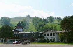
Bass Lake Provincial Park and the Copeland Forest Resources Management Area are located within the township. Three major ski resorts, Mount St. Louis Moonstone, Horseshoe Resort, and Hardwood Ski and Bike, are also located within Oro-Medonte.
Transportation
Highway 400, Highway 11 and Highway 12 pass through Oro-Medonte. Penetanguishene Road, a historic colonization road and a former part of Highway 93, defines most of Oro-Medonte's boundary with the neighbouring township of Springwater.
The Lake Simcoe Regional Airport is located in the township near the community of Guthrie.
Demographics
| Canada census – Oro-Medonte community profile | |||
|---|---|---|---|
| 2011 | 2006 | 2001 | |
| Population: | 20,078 (0.2% from 2006) | 20,031 (9.4% from 2001) | 18,315 (9.7% from 1996) |
| Land area: | 586.90 km2 (226.60 sq mi) | 586.65 km2 (226.51 sq mi) | 586.65 km2 (226.51 sq mi) |
| Population density: | 34.2/km2 (89/sq mi) | 34.1/km2 (88/sq mi) | 31.2/km2 (81/sq mi) |
| Median age: | 42.5 (M: 42.2, F: 42.9) | 40.0 (M: 39.6, F: 40.3) | |
| Total private dwellings: | 8565 | 8382 | 7667 |
| Median household income: | $69,274 | $60,169 | |
| References: 2011[1] 2006[17] 2001[18] | |||
Climate
| Climate data for Oro-Medonte | |||||||||||||
|---|---|---|---|---|---|---|---|---|---|---|---|---|---|
| Month | Jan | Feb | Mar | Apr | May | Jun | Jul | Aug | Sep | Oct | Nov | Dec | Year |
| Record high °C (°F) | 10.0 (50) |
13.0 (55.4) |
23.0 (73.4) |
29.5 (85.1) |
32.5 (90.5) |
34.0 (93.2) |
37.5 (99.5) |
34.0 (93.2) |
32.5 (90.5) |
27.0 (80.6) |
21.5 (70.7) |
17.0 (62.6) |
37.5 (99.5) |
| Average high °C (°F) | −3.6 (25.5) |
−2.7 (27.1) |
2.9 (37.2) |
10.7 (51.3) |
18.2 (64.8) |
22.5 (72.5) |
25.7 (78.3) |
24.2 (75.6) |
19.3 (66.7) |
12.2 (54) |
5.8 (42.4) |
−0.7 (30.7) |
11.2 (52.2) |
| Daily mean °C (°F) | −8.4 (16.9) |
−7.7 (18.1) |
−2.1 (28.2) |
5.7 (42.3) |
12.9 (55.2) |
17.1 (62.8) |
20.6 (69.1) |
19.4 (66.9) |
14.8 (58.6) |
8.2 (46.8) |
2.2 (36) |
−4.8 (23.4) |
6.5 (43.7) |
| Average low °C (°F) | −13.1 (8.4) |
−12.6 (9.3) |
−7.0 (19.4) |
0.8 (33.4) |
7.5 (45.5) |
11.5 (52.7) |
15.5 (59.9) |
14.6 (58.3) |
10.2 (50.4) |
3.9 (39) |
−1.3 (29.7) |
−8.8 (16.2) |
1.8 (35.2) |
| Record low °C (°F) | −37.0 (−34.6) |
−37.0 (−34.6) |
−30.0 (−22) |
−15.0 (5) |
−3.5 (25.7) |
0.5 (32.9) |
7.0 (44.6) |
4.0 (39.2) |
−3.0 (26.6) |
−6.0 (21.2) |
−9.0 (15.8) |
−35.0 (−31) |
−37.0 (−34.6) |
| Average precipitation mm (inches) | 103.1 (4.059) |
68.1 (2.681) |
71.3 (2.807) |
72.2 (2.843) |
77.6 (3.055) |
76.4 (3.008) |
77.4 (3.047) |
102.4 (4.031) |
95.5 (3.76) |
89.7 (3.531) |
102.5 (4.035) |
107.3 (4.224) |
1,043.2 (41.071) |
| Average rainfall mm (inches) | 13.9 (0.547) |
15.4 (0.606) |
38.4 (1.512) |
60.9 (2.398) |
77.3 (3.043) |
76.4 (3.008) |
77.4 (3.047) |
102.4 (4.031) |
95.3 (3.752) |
86.5 (3.406) |
77.1 (3.035) |
29.6 (1.165) |
750.6 (29.551) |
| Average snowfall cm (inches) | 89.2 (35.12) |
59.6 (23.46) |
32.9 (12.95) |
11.3 (4.45) |
0.4 (0.16) |
0 (0) |
0 (0) |
0 (0) |
0 (0) |
3.2 (1.26) |
25.4 (10) |
77.7 (30.59) |
292.6 (115.2) |
| Average precipitation days (≥ 0.2 mm) | 16.9 | 11.8 | 12.4 | 12.0 | 12.8 | 11.7 | 9.8 | 12.5 | 13.6 | 15.3 | 15.7 | 16.9 | 161.3 |
| Average rainy days (≥ 0.2 mm) | 2.6 | 2.3 | 6.5 | 10.6 | 12.7 | 11.7 | 9.8 | 12.5 | 13.6 | 15.0 | 12.3 | 4.5 | 114.2 |
| Average snowy days (≥ 0.2 cm) | 14.8 | 10.2 | 6.5 | 2.2 | 0.17 | 0 | 0 | 0 | 0 | 0.73 | 4.7 | 13.4 | 52.7 |
| Source: Environment Canada[19] | |||||||||||||
See also
References
- 1 2 3 "Oro-Medonte census profile". 2011 Census of Population. Statistics Canada. Retrieved 2012-03-06.
- ↑ Ref.Cities Of Canada Reference Guide
- ↑ Hill, Daniel G. The Freedom Seekers: Blacks in Early Canada. 1st Stoddart edition, 1992. p18
- ↑ Hill, PAC. C.O. 42 (Q 326) Vol. 363, p. 117; as cited by Gary French: Men of Colour, pp. 12-13. Stroud, Ont: Kaste Books, 1978.
- ↑ Reid, Dennis. A Concise History of Canadian Painting. 2nd Edition. Toronto: Oxford University Press, 1988. ISBN 0-19-540663-X.
- ↑ Directions to Edgar
- ↑ Oro African Methodist Episcopal Church National Historic Site. Canadian Register of Historic Places.
- ↑ Legend of the Drinking Gourd, W. Allen Fisher, 1973, W. A. and M. W. Fisher, publishers
- ↑ Men of Colour, Gary French, 1978, Kaste Books, Stroud Ontario Canada, publishers
- ↑ Township of Oro-Medonte
- 1 2
- 1 2
- ↑ Ref
- ↑
- ↑ Ref
- ↑ Ref
- ↑ "2006 Community Profiles". Canada 2006 Census. Statistics Canada. March 30, 2011. Retrieved 2012-03-06.
- ↑ "2001 Community Profiles". Canada 2001 Census. Statistics Canada. February 17, 2012. Retrieved 2012-03-06.
- ↑ Environment Canada — Canadian Climate Normals 1971–2000, accessed 9 May 2013
External links
| Wikimedia Commons has media related to Oro–Medonte. |
 |
Tay | Severn | Orillia | |
| Springwater | |
Lake Simcoe | ||
| ||||
| | ||||
| Barrie | Kempenfelt Bay of Lake Simcoe / Innisfil |