Oryahovo Heights
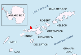

Oryahovo Heights (Oryahovski Vazvisheniya \o-'rya-hov-ski v&-zvi-'she-ni-ya\) are the ice-covered heights of elevation 340 m extending 6 km in north-south direction in central and eastern Ioannes Paulus II Peninsula, Livingston Island in the South Shetland Islands, Antarctica. They are linked to Snow Peak to the southeast by two saddles separated by the small ice dome of Casanovas Peak described first by Àlex Simón i Casanovas from the Spanish Antarctic Programme in the 2000/01 austral summer.
They are named after the town of Oryahovo in northwestern Bulgaria.
Location
The heights are centered at 62°32′09″S 60°45′00″W / 62.53583°S 60.75000°WCoordinates: 62°32′09″S 60°45′00″W / 62.53583°S 60.75000°W (British mapping in 1968, Bulgarian in 2009).
Maps
- L.L. Ivanov et al. Antarctica: Livingston Island and Greenwich Island, South Shetland Islands. Scale 1:100000 topographic map. Sofia: Antarctic Place-names Commission of Bulgaria, 2005.
- L.L. Ivanov. Antarctica: Livingston Island and Greenwich, Robert, Snow and Smith Islands. Scale 1:120000 topographic map. Troyan: Manfred Wörner Foundation, 2009. ISBN 978-954-92032-6-4
References
This article includes information from the Antarctic Place-names Commission of Bulgaria which is used with permission.