Ouderkerk aan de Amstel
| Ouderkerk aan de Amstel | |
|---|---|
| Town | |
|
Entering the town of Ouderkerk aan de Amstel | |
 | |
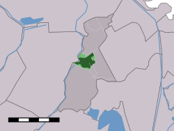 The town centre (dark green) and the municipal boundaries (light green) of Ouderkerk aan de Amstel in the municipality of Ouder-Amstel. | |
| Coordinates: 52°18′N 4°55′E / 52.300°N 4.917°ECoordinates: 52°18′N 4°55′E / 52.300°N 4.917°E | |
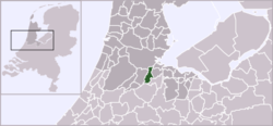
| Country | Netherlands |
| Province | North Holland |
| Municipality | Ouder-Amstel / Amstelveen |
| Area | |
| • Total | 26.18 km2 (10.11 sq mi) |
| Population (2005) | |
| • Total | 8,228 |
| • Density | 310/km2 (810/sq mi) |
| Time zone | CET (UTC+1) |
| • Summer (DST) | CEST (UTC+2) |

Ouderkerk aan de Amstel is a village in the Dutch province of North Holland. It is largely a part of the municipality of Ouder-Amstel, and lies about 9 km south of Amsterdam. A small part of the town lies in the municipality of Amstelveen. It is connected to Amsterdam by the river Amstel. There is another village called Ouderkerk in South-Holland, Ouderkerk aan den IJssel.
In 2001, the town of Ouderkerk aan de Amstel had 7,256 inhabitants. The built-up area of the town was 1.5 km², and contained 3,043 residences.[1] The broader area of Ouderkerk aan de Amstel, which includes residences on the periphery of the village and in the surrounding countryside, has a population of around 7,480.[2]
The town is the location of the Beth Haim of Ouderkerk aan de Amstel, the oldest Jewish cemetery in the Netherlands.[3]
 Drawing bridge: de Kerkbrug
 De Zwaan ("The Swan") windmill
 View to de Ronde Hoep
References
- ↑ Statistics Netherlands (CBS), Bevolkingskernen in Nederland 2001. (Statistics are for the continuous built-up area).
- ↑ Statistics Netherlands (CBS), Statline: Kerncijfers wijken en buurten 2003-2005. As of 1 January 2005.
- ↑ L. alvarez Vega, the Beth Haim of Ouderkerk aan de Amstel, 1994