Outer old Seoul
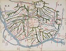
Outer old Seoul or Seongjeosimni (Hangul: 성저십리, Hanja: 城底十里) was a surrounding area of old Seoul or Hanseong-bu (한성부), established in Joseon period. This area makes up an isle of Yeouido and several districts of Seoul today: Eunpyeong, Mapo, Seodaemun, Yongsan, Dongdaemun, Seongbuk, Gangbuk, and Seongdong.
Outer old Seoul was a part of Joseon's capital city, Hanseongbu. This means it did belong to neither of the two surrounding counties around old Seoul - Goyang and Yangju. Unlike inner old Seoul, often referred as 'the inside area of the Eight Gates of Seoul' or 'Sadaemun-an'(사대문안), the number of residents was relatively smaller and deforestation and funeral burials within the area were highly regulated or prohibited by the authorities. It was divided into several districts or Bang(방)s - Yeonhui(연희방), Sangpyeong(상평방), Seogang(서강방), Yongsan(용산방), Sungsin(숭신방), Inchang(인창방), and Dumo(두모방) (at the time of late Joseon).
Although the exact boundary is unknown, assumed natural borders are thought to be small rivers/streams of Hongje, Ui, and Jungnang, the Han River and Bukhansan mountain.
In 1914, most of outer old Seoul, excepting small neighbourhoods of Changsin and Sungin, some eastern part of Mapo and the west of Yongsan, was annexed into Goyang county by the Japanese colonial government as a political [colonial] scheme to minimise colonial Seoul or then Gyeongseong-bu (경성부). From 1936 through 1949, most of this area was re-incorporated into Seoul.
References
- 최완기, 1997, <<한양>>, 서울: 교학사. (in Korean)
- 고양시사편찬위원회, 2005, <<高陽市史>>, 고양: 고양시사편찬위원회. (in Korean)
- 네이버 지식백과 지명편 (http://terms.naver.com/list.nhn?categoryId=2281&mobile) (in Korean)