Hășdate River
| Hășdate | |
| River | |
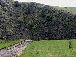
 The Hășdate Gorge between Cheile Turzii and Corneşti | |
| Countries | Romania |
|---|---|
| Counties | Cluj County |
| Tributaries | |
| - left | Dumbrava Filei, Micuș |
| Villages | Hăşdate, Ciurila, Petreștii de Jos |
| Mouth | Arieș |
| - location | Corneşti |
| - coordinates | 46°31′34″N 23°41′10″E / 46.526°N 23.686°ECoordinates: 46°31′34″N 23°41′10″E / 46.526°N 23.686°E |
| Length | 32 km (20 mi) |
| Basin | 213 km2 (82 sq mi) |
| Progression | Arieș→ Mureș→ Tisza→ Danube→ Black Sea |
The Hășdate (also: Hăjdate, in Hungarian: Hesdát-patak) is a small river in the Apuseni Mountains, Cluj County, western Romania. It is a left tributary of the river Arieș. It flows through the municipalities Săvădisla, Ciurila and Petreștii de Jos, and joins the Arieș at Corneşti, near Turda. It is fed by several smaller streams, including Dumbrava Filei, Săliște, Micuş, Negoteasa, Livada and Petridul. It formed the Cheile Turzii, a narrow river gorge.
References
| Wikimedia Commons has media related to Hăşdate River. |
- Administrația Națională Apelor Române - Cadastrul Apelor - București
- Institutul de Meteorologie și Hidrologie - Rîurile României - București 1971
- Capitolul 3 Apa
- Trasee turistice - județul Cluj
Maps
This article is issued from Wikipedia - version of the 7/21/2016. The text is available under the Creative Commons Attribution/Share Alike but additional terms may apply for the media files.