Pennsylvania Route 199
| ||||
|---|---|---|---|---|
 | ||||
| Route information | ||||
| Maintained by PennDOT | ||||
| Length: | 4.833 mi[1] (7.778 km) | |||
| Existed: | 1974 – present | |||
| Major junctions | ||||
| South end: |
| |||
| North end: |
| |||
| Location | ||||
| Counties: | Bradford | |||
| Highway system | ||||
| ||||

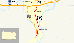
Pennsylvania Route 199 (PA 199) is a 5-mile-long (8.0 km), north–south state highway located in Bradford County in Pennsylvania. The southern terminus is at US 220 near Athens. The northern terminus is the New York state line in Sayre, Pennsylvania.
Route description
PA 199 goes by 3 names along its route. They include Keystone Avenue, Mohawk Street, and Spring Street.[2]
The route starts in Athens Township, outside the borough of Athens, at an intersection with US 220. The route parallels the Susquehanna River for a short distance in Athens before the route enters the borough of Sayre, Pennsylvania. Before entering the state of New York, the eastbound entrance/exit ramp for NY 17 (future Interstate 86) intersects at the route. The route then meets NY 34 at the New York state line.[2]
History
PA 199 was once signed elsewhere, in Erie County between PA 5 and US 20 from 1928, until the mid-1960s, when it was decommissioned.[3][4] In 1974, the route number was used again, mostly on the old alignment of US 220 through the 3 towns that it went through once the US 220 bypass was complete.[5][6]
The current southern terminus of PA 199 is about 300 feet (91 m) north of the original southern terminus at US 220. The original road met US 220 at a much sharper angle than the present intersection which was built in 2008.[1]
Major intersections
The entire route is in Bradford County.
| Location | mi[1] | km | Destinations | Notes | |
|---|---|---|---|---|---|
| Athens Township | 0.000 | 0.000 | |||
| Sayre | 4.833 | 7.778 | Exit 61, Eastbound entrance and exit in Pennsylvania | ||
| 4.833 | 7.778 | New York state line, southern terminus of NY 34 | |||
| 1.000 mi = 1.609 km; 1.000 km = 0.621 mi | |||||
See also
 U.S. Roads portal
 Pennsylvania portal
References
- 1 2 3 Bureau of Maintenance and Operations (January 2015). Roadway Management System Straight Line Diagrams (Report) (2015 ed.). Pennsylvania Department of Transportation. Retrieved June 30, 2015.
- Bradford County (PDF)
- 1 2 Google (December 25, 2012). "Pennsylvania Route 199" (Map). Google Maps. Google. Retrieved December 25, 2012.
- ↑ ftp://ftp.dot.state.pa.us/public/pdf/BPR_PDF_FILES/Maps/Type_10_GHS_Historical_Scans/Erie_1941.pdf
- ↑ ftp://ftp.dot.state.pa.us/public/pdf/BPR_PDF_FILES/Maps/Type_10_GHS_Historical_Scans/Erie_1968.pdf
- ↑ ftp://ftp.dot.state.pa.us/public/pdf/BPR_PDF_FILES/Maps/Type_10_GHS_Historical_Scans/Bradford_1964.pdf
- ↑ ftp://ftp.dot.state.pa.us/public/pdf/BPR_PDF_FILES/Maps/Type_10_GHS_Historical_Scans/Bradford_1978.pdf