Pennsylvania Route 328
| ||||
|---|---|---|---|---|
 | ||||
| Route information | ||||
| Maintained by PennDOT | ||||
| Length: | 13.228 mi[1] (21.288 km) | |||
| Existed: | 1961 – present | |||
| Major junctions | ||||
| West end: |
| |||
|
| ||||
| East end: |
| |||
| Location | ||||
| Counties: | Tioga, Bradford | |||
| Highway system | ||||
| ||||

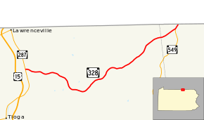
Pennsylvania Route 328 (designated by the Pennsylvania Department of Transportation as SR 328) is a 13.2-mile-long (21.2 km) state highway located in Tioga and Bradford counties in Pennsylvania. The western terminus is at Pennsylvania Route 287 in Tioga Junction. The eastern terminus is the New York state line near Millerton.
Route description
Route 328 begins at an intersection in Tioga Junction with Route 287. The route progresses eastward as a residential road through Tioga Junction, turning southeastward after Hillside Terrace. After this curve, Route 328 leaves Tioga Junction a two-lane local road through woodlands. The road curves several times from east, southeast and northeast directions before maintaining a southeastward at a field near Burrows Hollow Road. After Lyman Stone Road, Route 328 turning southeastward through forests and fields before curving eastward through fields. At the intersection with Button Hill Road, Route 328 turns to the northeast into Jackson Summit. Starting in Jackson Summit, the route parallels the former right-of-way of the Erie Railroad's Tioga Division, serving as a residential highway through Jackson Summit. At the intersection with Hudson Hill Road, Route 328 turns to the east entering the hamlet of Trowbridge, where it passes to the south of the former Trowbridge station.[2]
After the hamlet of Trowbridge, Route 328 remains a rural highway, turning to the northeast through the fields in the area. After the intersection with Alder Run Road, the highway becomes residential for a short stretch. Soon after, the route enters the census-designated place of Millerton and gains the name of Main Street. Route 328 passes a mix of commercial businesses and residential homes until leaving Millerton after the intersection with Bly Road. The route remains known as Main Street for a short distance, changing names to Hammond Creek Road upon crossing the county line into Bradford County. Route 328 enters Wells Township progressing to the northeast of the hamlet of Mosherville. In the area north of Mosherville, Route 549 intersects with Route 328 and terminates. There, Route 328 takes the right-of-way from Route 549 and progresses northeast to the New York state line, where the designation terminates. The route continues northward as New York State Route 328.[2]
Major intersections
| County | Location | mi[1] | km | Destinations | Notes |
|---|---|---|---|---|---|
| Tioga | Tioga Township | 0.000 | 0.000 | Western terminus of Route 328; Village of Tioga Junction | |
| Bradford | Wells Township | 12.827 | 20.643 | Northern terminus of Route 549 | |
| 13.228 | 21.288 | Eastern terminus of Route 328; Pennsylvania–New York state line | |||
| 1.000 mi = 1.609 km; 1.000 km = 0.621 mi | |||||
See also
 U.S. Roads portal
 Pennsylvania portal
References
- 1 2 Bureau of Maintenance and Operations (January 2015). Roadway Management System Straight Line Diagrams (Report) (2015 ed.). Pennsylvania Department of Transportation. Retrieved June 30, 2015.
- Tioga County (PDF)
- Bradford County (PDF)
- 1 2 Microsoft; Nokia (July 12, 2011). "Overview map of Pennsylvania Route 328" (Map). Bing Maps. Microsoft. Retrieved July 12, 2011.
External links
- Kitsko, Jeffrey J. (2016). "PA 328". Pennsylvania Highways.