Pax Julia
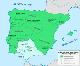
Pax Iulia (also known as Colonia Civitas Pacensis) was a city in the Roman province of Lusitania (today situated in the Portuguese municipality of Beja).
History
The region was inhabited during 400 B.C. by Celtic tribes, but there are indications that Carthaginian settlers occupied the territory, from the writings of 2nd century scholars Polybius and Claudius Ptolemy.
In 48 B.C., it was renamed Pax Iulia (referring to the "peace of the gens Julia") by Julius Caesar following the peace between Rome and the Lusitani. The settlement became the centre of the conventus iuridicus Pacensis, (in the Roman province of Lusitania), since it was located on a strategic roadway junction with connection Myrtilis Iulia (a harbor city along the Guadiana river).
Sometime between 31 and 27 B.C., during the reign of the emperor Augustus, the city was granted the status of municipium following the Battle of Actium, and the colonists ascribed to the gens Galeria.[1] It was a this time that a new designation began to appear: Pax Augusta (referring to the peace of Augustus) as mentioned by Strabo,[2]
20th century
Archeology excavations during the 20th century uncovered the remains of a large Roman temple, 30 by 19.4 metres (98 ft × 64 ft), dating to the first century A.D. located within the settlement's forum, with several inscriptions, Roman arches, fortifications and an aqueduct.[3] Possible locations for the Theater and Amphitheater were deduced from the urban layout.
-
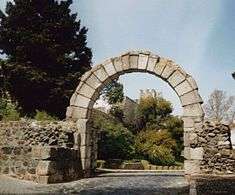
Roman arch from Beja
-
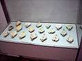
Roman oil lamps; Rainha D. Leonor Museum
-
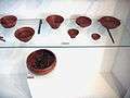
Terra sigillata (ceramic ware made of porous clay fired at low heat); Rainha D. Leonor Museum
-
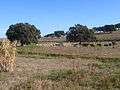
Roman dam, Cuba Municipality, Beja
-
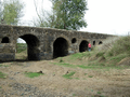
Roman bridge over the Rio Odivelas, municipality of Cuba
-

Roman Ruins of São Cucufate, municipality of Vidigueira
References
Notes
- ↑ Faria, António Marques de (1989), Sobre a data da fundação de Pax Iulia (in Portuguese) (28), Conimbriga, pp. 101–109, retrieved 2 November 2011
- ↑ Faria, António Marques de (1997). "De novo em torno da fundação de Pax Iulia: um exercício de "controversismo" (António Marques de Faria) - Academia.edu" (in Portuguese). Vipasca. pp. 171–185. Retrieved 2 November 2011.
- ↑ "Arqueologia Templo romano descoberto em Beja é o maior de Portugal e um dos maiores da Península Ibérica", Expresso (in Portuguese), AEIOU-Investimentos Multimédia, S.A., retrieved 30 July 2009
Coordinates: 38°01′04″N 7°51′55″W / 38.0178°N 7.8653°W