Pale of Calais
| Pale of Calais | ||||||||||
| Calaisis | ||||||||||
| Overseas possession of England | ||||||||||
| ||||||||||
| ||||||||||
| Motto Veritas Temporis filia "Truth, the daughter of Time" | ||||||||||
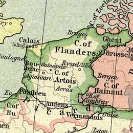 The Pale of Calais (yellow) in 1477. | ||||||||||
| Capital | Calais | |||||||||
| Languages | English, French, Flemish | |||||||||
| Religion | Roman Catholic | |||||||||
| Political structure | Overseas possession | |||||||||
| Lord | ||||||||||
| • | 1346–1377 | Edward III (first) | ||||||||
| • | 1553–1558 | Mary I (last) | ||||||||
| Governor | ||||||||||
| • | 1353 | Reynold Cobham (first) | ||||||||
| • | 1553–1558 | Thomas Wentworth (last) | ||||||||
| Historical era | Late Middle Ages | |||||||||
| • | Battle of Crécy | 26 August 1346 | ||||||||
| • | Treaty of Brétigny | 8 May 1360 | ||||||||
| • | Siege of Calais | 1 January 1558 | ||||||||
| • | Peace of Vervins | 2 May 1598 | ||||||||
| Area | ||||||||||
| • | 1477 | 52 km² (20 sq mi) | ||||||||
| Currency | Pound sterling | |||||||||
| ||||||||||
| Today part of | | |||||||||
.svg.png)
The Pale of Calais (French: le Calaisis) is a historical region in modern-day France that was controlled by the monarchs of England following the Battle of Crécy in 1346. Pale is an archaic English term for "area, jurisdiction".[1] The capture by the English is the subject of Auguste Rodin's 1889 sculpture The Burghers of Calais. In 1558, the expanding Kingdom of France took the Pale of Calais in the aftermath of the Siege of Calais.
History
Calais fell after the Battle of Crécy in 1346 to Edward III of England following a desperate siege. Its seizure gave him a defensible outpost where his army could regroup, and the city's position on the English Channel meant that, once it was taken, it could be resupplied easily by sea. Its retention was confirmed under the Treaty of Brétigny, signed on 8 May 1360, when Edward renounced the throne of France, in return for substantial lands in France, namely Aquitaine and the area around Calais.[2] By 1453, at the end of the Hundred Years' War, it was the only part of mainland France to remain in English hands.
While it was possible to resupply and defend Calais easily by sea, in the absence of any natural defence it depended on fortifications maintained and built up at some expense. However, its main defence had been that both the French and the Burgundians coveted the city, but each preferred to see it under the English rather than their rival. Changing political circumstances with the division of Burgundian interests in the Low Countries between France and Spain meant that, in 1550 when England surrendered the area around Boulogne,[3] which Henry VIII had taken in 1544, the approaches to Calais were opened.
The Pale of Calais remained controlled by England until lost by Mary I of England to France in 1558 when, following secret preparations, 30,000 French troops, led by Francis, Duke of Guise, took the town of Calais. Its loss was recognised under the Treaty of Cateau-Cambrésis (1559). In England there was shock and disbelief at the loss of this final Continental territory. The chronicler Raphael Holinshead reported that a few months later Queen Mary, on her death bed, told her family: "When I am dead and opened, you shall find 'Calais' lying in my heart".[4] However the loss of the Pale of Calais was not as severe on the English economy as might have been expected, as by this time England was focusing its trade on the Netherlands.[5]
During the English occupation, the people of the Pale of Calais retained their identity as French and Flemish speakers.[6]
Geography
The area of the Pale of Calais comprised the communes of Andres, Balinghem, Bonningues-lès-Calais, Calais, Campagne-lès-Guines, Coquelles, Coulogne, Fréthun, Guemps, Guînes, Hames-Boucres, Hervelinghen, Marck, Nielles-lès-Calais, Nouvelle-Église, Offekerque, Oye-Plage, Peuplingues, Pihen-lès-Guînes, Sangatte, Saint-Pierre (Calais absorbed Saint-Pierre-lès-Calais inhabited with 33 290 inhabitants in 1885, now southern part of Calais), Saint-Tricat, and Vieille-Église.
The area of the Pale of Calais is difficult to define because the boundaries were not clearly defined, due to swampy land and artificial waterways,[7] and were constantly changing, but extended from Gravelines almost to Wissant and covered about 20 square miles (52 km2).[3] Furthermore, the French were continually reclaiming small pieces of the territory, particularly in the southwest.[3]
Much of the area of the Pale consisted of wetlands, and the territory was roughly divided into highlands in the west and lower country in the east.[3]
See also
- History of Calais
- Hundred Years' War
- English overseas possessions
- English claims to the French throne
- The Pale of Ireland
References
- ↑ "Pale (noun)". The New Oxford American Dictionary (3rd ed.). 2013.
See also: The English Pale in Ireland. - ↑ Fisher, H.A.L. (1936). A History of Europe. Great Britain: Edward Arnold & Co. p. 322.
- 1 2 3 4 Sandeman, George Amelius Crawshay. Calais under English Rule. p. 114.
- ↑ Bentley, James (1991). The Gateway to France. London: Viking. p. 10. ISBN 0670832065. Retrieved 26 September 2016.
- ↑ Hunt, Jocelyn (1999). The Renaissance. New York: Routledge. p. 97. ISBN 0-203-98177-4.
- ↑ Dumitrescu, Theodor (2007). The early Tudor court and international musical relations. England: Ashgate Publishing Limited. p. 53. ISBN 978-0-7546-5542-8.
- ↑ Darian-Smith, Eve (1999). Bridging divides: the Channel Tunnel and English legal identity in the new Europe. University of California Press. p. 77. ISBN 0-520-21610-5.
Coordinates: 50°56′53″N 1°51′23″E / 50.94806°N 1.85639°E