Pamdenec, New Brunswick
| Pamdenec | |
|---|---|
| Village | |
|
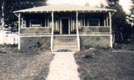
Typical Pamdenec Cottage | |
 Pamdenec | |
| Coordinates: 45°18′47″N 66°11′38″W / 45.313°N 66.194°WCoordinates: 45°18′47″N 66°11′38″W / 45.313°N 66.194°W | |
| Country | Canada |
| Province | New Brunswick |
| County | Kings County |
| Incorporated | 1966 |
| Time zone | AST (UTC-4) |
| • Summer (DST) | ADT (UTC-3) |
| Canadian postal code | E5K |
| Area code(s) | 506 |
| Telephone Exchange | 217, 738, 757 |
| NTS Map | 021G08 |
| GNBC Code | DBEFJ |
The village of Pamdenec was a small bedroom community located on the Saint John River, 1.85 kilometres (1.15 mi) north of Grand Bay, in Westfield Parish, Kings County, New Brunswick, Canada. Pamdenec had a post office from 1924 to 1968, was incorporated as a village in 1966, and became part of the village of Grand Bay in 1972.[1]
"Pamdenec" is a Maliseet name, meaning "little hill".[2] The village was formerly called Hillside and in 1866, under that name, was a farming community consisting of approximately 75 families.[1]
In 2011, the area was listed on the Canadian Register of Historic Places for its cultural value as the site of a group of summer cottages owned by members of the Jewish community of Saint John, mainly from the 1920s to the 1960s.[3]
References
- 1 2 "Pamdenic". Where Is Home? New Brunswick Communities Past and Present. Provincial Archives of New Brunswick. Retrieved 25 July 2015.
- ↑ Ganong, W. F. (1906). "Additions and Corrections to Monographs on the Place-Nomenclature, Cartography, Historic Sites, Boundaries and Settlement-origins of the Province of New Brunswick". Transactions of the Royal Society of Canada, Second Series, Vol. 12, Section 2. p. 40. Retrieved 25 July 2015.
- ↑ "Pamdenec Summer Community". Canada's Historic Places. Parks Canada Agency. Retrieved 25 July 2015.