Panachaiko
| Panachaiko | |
|---|---|
.JPG) View of the second highest peak, during winter | |
| Highest point | |
| Peak | Palavou Pyrgos |
| Elevation | 1,926 m (6,319 ft) [1] |
| Coordinates | 38°12′9″N 21°52′8″E / 38.20250°N 21.86889°ECoordinates: 38°12′9″N 21°52′8″E / 38.20250°N 21.86889°E |
| Dimensions | |
| Length | 20 km (12 mi) |
| Geography | |
| Country | Greece |
| Regional unit | Achaea |
The Panachaiko (Greek: Παναχαϊκό, Panachaean"), also known as Vodias (Βοδιάς) in the Middle Ages, is a mountain range in Achaea, southern Greece. It spans about 20 km in length from north to south, and 15–20 km from east to west. It is the northernmost mountain range in the Peloponnese. The highest point, named Palavou Pyrgos, is 1,926 m.[1]
The mountain is home to two shelters, Greece's largest wind farm with 40 generators, which opened in 2006, and two communications stations. Snow is common in areas over 1,000 m in the winter. Paragliding is common in areas under 1,100 m. Due to overgrazing, frequent forest fires, and the appropriation of land for housing, the mountain's ecology and soil have suffered greatly, to the extent that much of the soil is now barren or can only support herbaceous vegetation. The range is sparsely forested, mainly on its western and southern slopes, while the most fertile areas lie on the eastern and western slopes.
Gallery
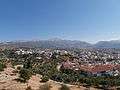 Panachaiko from the castle of Patras.
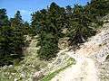 Ascending path
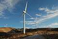 Aeolic park
 Rakita plateau
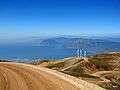 Road to aeolic park
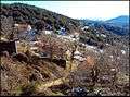 Pigi (Zoumpata) village
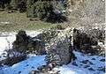 Sapia Vrysi ruins
References
| Wikimedia Commons has media related to Panachaiko Mountain. |