Pantaron Mountain Range
| Pantaron Mountain Range | |
|---|---|
| Central Cordillera | |
.svg.png) Pantaron Mountain Range | |
| Highest point | |
| Coordinates | 7°44′35.02″N 125°25′49.01″E / 7.7430611°N 125.4302806°ECoordinates: 7°44′35.02″N 125°25′49.01″E / 7.7430611°N 125.4302806°E |
| Dimensions | |
| Length | 200 km (120 mi) NS |
| Area | 12,600 km2 (4,900 sq mi) [1] |
| Geography | |
| Country | Philippines |
| Region | Northern Mindanao, Caraga and Southern Mindanao |
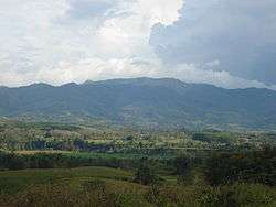
Pantaron Mountain Range, also called the Central Cordillera of Mindanao, Philippines is a mountain range straddling across the provinces of Misamis Oriental, Bukidnon, Agusan del Norte, Agusan del Sur, Davao del Norte and Davao del Sur.[1] The range contains one of the last remaining old growth or primary forest blocks in Mindanao.[1][2] Major rivers in the island also has their headwaters in the mountain range including Mindanao River, Pulangi River, Davao River, Tagoloan River and major tributaries of Agusan River.
Ethnic tribal communities such as the Manobos, Higaonons and Bukidnons are the inhabitants of the area. Ancestral domain claims within the boundaries of the mountain range has also been identified by the government for these ethnic minorities.[2]
References
- 1 2 3 Balane, Walter I. "'Pantaron Range, one of PH's largest remaining forest blocks' – MinDA". Bukidnon News. Bukidnon News. Retrieved 3 October 2013.
- 1 2 Poffenberger, Mark. "Communities and Forest Management in Southeast Asia". Asia Forest Network. Working Group on Community Involvement in Forest Management (WG-CIFM). Retrieved 3 October 2013.