Parco naturale regionale dell'Antola
| Antola Natural Regional Park | |
|---|---|
| Parco naturale regionale dell'Antola | |
|
IUCN category V (protected landscape/seascape) | |
|
Winter panorama from Monte Antola | |
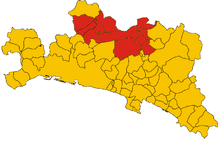
| Location | Metropolitan City of Genoa, Italy |
| Nearest city | Genova |
| Coordinates | 44°34′26″N 9°08′56″E / 44.574°N 9.149°ECoordinates: 44°34′26″N 9°08′56″E / 44.574°N 9.149°E |
| Area | 4,837 ha (11,950 acres) |
| Established | 1989, 1995 |
| Governing body | Ente Parco dell'Antola (Torriglia) |
| www.parcoantola.it | |

The Antola Natural Regional Park (in Italian Parco naturale regionale dell'Antola) is a natural park in Metropolitan City of Genoa (Liguria, Italy). It gets the name from the highest mountain of the area, Monte Antola.
History
The natural park was established by the l.r. (regional law, in Italian legge regionale) nr. 16, April 9, 1985 as modified by the l.r. nr. 12, February 22, 1995.[1] Since April 30, 2014 the Environmental Management System of the park is certified according to ISO 14001 standards.[2]
Geography

Situated in the inland of the Italian Riviera between Genova and Rapallo, the park protects a scenic portion of the Ligurian Apennines. The protected area is mainly located near the border with Piemonte and south of the Apenninic watershed dividing Pianura Padana (tributary of the Adriatic Sea) from the Ligurian Sea drainage basin. It covers over 48 square kilometres[3] (that is 4,837 ha (11,950 acres)), plus 5,832 ha under a lesser form of environmental protection named aree contigue (contiguous areas).
The park encompasses the uppermost part of four short valleys:
- Val Vobbia
- Val Pentemina
- Val Brevenna
- Val Trebbia.
Concerned municipalities

The natural park is shared among twelve different municipalities: Busalla, Crocefieschi, Fascia, Gorreto, Montebruno, Propata, Ronco Scrivia, Rondanina, Savignone, Torriglia, Valbrevenna, Vobbia.[3]
Main summits of the park
Among the highest summits located in the park can be cited Monte Antola (1597 m), Monte Buio (1,497 m) and Monte Prelà (1406 m). Also relevant for some aspects are Rocche del Reopasso (956 m), a rocky summit with interesting climbing routes and a via ferrata, or Monte Reale (902 m), bearing an old Catholic sanctuary on its top and a free mountain hut all-year open next to the church.[4]
Wildlife
The most renowned among the animal species living in the park are wolves, that became extinct in the area around 1850 because of the increased number of inhabitants of that period. They reappeared around 150 years later coming from the central Apennine at the end of the XX century, and are now an habitual presence in the protected area. They mostly prey on roe and fallow deer, which have also reappeared in the park in the last decades. Birds of prey are well represented by Buteo buteo, Accipiter nisus, Falco tinnunculus and Pernis apivorus. Quite common is the European green woodpecker and, close to the streams, Alcedo atthis (common kingfisher), while the population of red-legged partridge is shrinking due to the decreasing amount of farmland.[5]
Transport
Antola park can be reached by car via motorway (Autostrada A7, exits of Busalla, Ronco Scrivia or Isola del Cantone) or trunk road (S.S. 35 dei Giovi, S.S. 226 di Valle Scrivia and S.S. 45 di Val Trebbia). It is also linked to Genova by the scenic Genova-Casella narrow-gauge railway.[6]
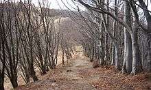
Hiking
Around 270 km of footpaths, mostly signposed, are available within the park. The Rifugio Parco Antola, a mountain hut located at 1460 m near the summit of monte Antola, was built by the Ente Parco and is now managed by the Club Alpino Italiano. It can accommodate up to 32 hikers or alpinists.[7]
References
- ↑ "Elenco ufficiale delle aree protette (EUAP) – 5º Aggiornamento – Supplemento ordinario n. 144 alla Gazzetta Ufficiale n. 205 del 4 settembre 2003" (PDF). www.parks.it. Ministero dell'ambiente e della tutela del territorio e del mare. Retrieved 2016-03-07.
- ↑ Environmental management system certification of the park in .pdf: www.parks.it
- 1 2 RAFL – Rapporto sullo Stato delle Foreste in Liguria 2008. Compagnia delle Foreste Srl and Regione Liguria. 2009. Retrieved 2016-03-07.
- ↑ "Rifugio di Monte Reale (902 mt)". www.parks.it. Retrieved 2016-03-19.
- ↑ Fabrizio Capecchi (1990). Un'isola fra i monti. Edizioni Croma. Retrieved 2016-03-12.
- ↑ "Facilities". www.parcoantola.it. Retrieved 2016-03-19.
- ↑ "Rifugio Parco Antola". www.rifugioantola.com. Retrieved 2016-03-12.
Bibliography
- Stefano Ardito (2006). Guida al Parco Naturale Regionale dell'Antola (in Italian). Erredì Grafiche Editoriali. ISBN 88-95023-00-5.
- Ente Parco Naturale Regionale dell'Antola (1999). Il parco naturale regionale dell'Antola. Guida rapida (in Italian). SAGEP. ISBN 88-7058-714-2.
- Alfred Uchman (2009). I fossili del Monte Antola (in Italian). Fondazione Luigi, Cesare e Liliana Bertora.
- Andrea Parodi, Alessio Schiavi (2015). La catena dell'Antola. 113 escursioni fra Scrivia, Trebia e Oltrepo sui monti delle quattro province (in Italian). Andrea Parodi Editore. ISBN 88-8887-316-3.
External links
![]() Media related to Parco naturale regionale dell'Antola at Wikimedia Commons
Media related to Parco naturale regionale dell'Antola at Wikimedia Commons