Parks Peak (Blaine County, Idaho)
| Parks Peak | |
|---|---|
 Parks Peak | |
| Highest point | |
| Elevation | 10,280 ft (3,130 m) |
| Prominence | 920 ft (280 m) [1] |
| Parent peak | Snowyside Peak |
| Coordinates | 43°58′02″N 114°55′58″W / 43.9671272°N 114.9328544°WCoordinates: 43°58′02″N 114°55′58″W / 43.9671272°N 114.9328544°W [2] |
| Geography | |
| Parent range | Sawtooth Range |
| Topo map | USGS Snowyside Peak |
| Climbing | |
| Easiest route | Scrambling, class 3 |

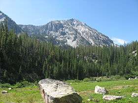
Parks Peak, at 10,280 feet (3,130 m) above sea level is a peak in the Sawtooth Range of Idaho. The peak is located in the Sawtooth Wilderness of Sawtooth National Recreation Area on the border of Blaine and Custer counties. The peak is located 2.78 mi (4.47 km) northeast of Snowyside Peak, its line parent, and 1.9 mi (3.1 km) northwest of McDonald Peak. Farley Lake is north of the peak and Bowknot and Toxaway lakes are west of the peak.[3][4][5]
References
- ↑ "Parks Peak, Idaho". Peakbagger.com. Retrieved January 4, 2013.
- ↑ "Parks Peak". Geographic Names Information System. United States Geological Survey. Retrieved January 4, 2013.
- ↑ Sawtooth National Forest (Map) (1998 ed.). Sawtooth National Forest, U.S. Forest Service.
- ↑ "Parks Peak". SummitPost.org. Retrieved January 4, 2013.
- ↑ "Parks Peak". Lists of John. Retrieved January 4, 2013.
This article is issued from Wikipedia - version of the 2/25/2016. The text is available under the Creative Commons Attribution/Share Alike but additional terms may apply for the media files.