Patagonia Lake
| Patagonia Lake | |
|---|---|
 | |
| Location | Santa Cruz County, Arizona, United States |
| Coordinates | 31°29′37″N 110°51′20″W / 31.49361°N 110.85556°WCoordinates: 31°29′37″N 110°51′20″W / 31.49361°N 110.85556°W |
| Type | reservoir |
| Primary inflows | Sonoita Creek |
| Basin countries | United States |
| Surface area | 260 acres (110 ha) |
| Average depth | 90 ft (27 m) |
| Surface elevation | 4,050 ft (1,230 m) |
| Settlements | Patagonia |
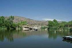
Patagonia Lake is a man-made reservoir in Santa Cruz County, Arizona, located southwest of the town of Patagonia, Arizona and northeast of Nogales.[1] The lake was created by damming Sonoita Creek,[2] and is a popular area for boating and sport fishing. Facilities are maintained by Arizona State Parks as part of Patagonia Lake State Park.
Fish species
References
- ↑ "Patagonia Lake State Park". DesertUSA.com.
- ↑ "Patagonia Lake, Arizona". Recreation Resource Management.
- Arizona Game and Fish Department, Information and Education Division (2007). Arizona Fishin' Holes. Phoenix, AZ: Arizona Game and Fish Department.
External links
This article is issued from Wikipedia - version of the 10/5/2015. The text is available under the Creative Commons Attribution/Share Alike but additional terms may apply for the media files.