Pennsylvania Route 307
| ||||
|---|---|---|---|---|
 | ||||
| Route information | ||||
| Maintained by PennDOT and City of Scranton | ||||
| Length: | 31.510 mi[1] (50.710 km) | |||
| Major junctions | ||||
| South end: |
| |||
|
| ||||
| North end: |
| |||
| Location | ||||
| Counties: | Lackawanna, Wyoming | |||
| Highway system | ||||
| ||||

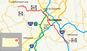
Pennsylvania Route 307 (PA 307) is a north–south route of the Pennsylvania Highway System that runs for 31 miles (50 km). The southern terminus is Pennsylvania Route 435 in Covington Township and the northern terminus is Pennsylvania Route 92 in Tunkhannock Township. The highway is called Scranton - Pocono Highway south of Scranton.
Route description
PA 307 begins at a Y intersection with PA 435 in Covington Township in Lackawanna County, heading northwest on four-lane undivided Scranton-Pocono Highway. The road runs through forested areas with some homes, coming to an intersection with PA 502 in the community of Fells Corners. The route heads through more woodland with some fields and development and comes to an interchange with I-380 at exit 20. Past this interchange, PA 307 continues through forests with some homes and enters Spring Brook Township, where it crosses PA 690 at Quinlan Corners in the community of Maple Lake. The road continues through rural land and enters Roaring Brook Township, where it heads across the forested Moosic Mountains, passing east of Coon Hill. The route heads to the east of the Williams Bridge Reservoir and curves to the north, narrowing to a three-lane road with one northbound lane and two southbound lanes. The road heads into a section of the borough of Dunmore and turns to the northwest.[2][3]
PA 307 enters the city of Scranton and becomes two-lane Moosic Street, passing to the north of Lake Scranton and curving west. The road gains a center left-turn lane and runs west-southwest through wooded areas with homes. The route becomes a three-lane road with one northbound lane and two southbound lanes and bends to the west-northwest, running through woodland and passing under an abandoned railroad line. PA 307 widens into a four-lane divided highway and crosses I-81, with a ramp from southbound I-81 to PA 307. Past this interchange, the route runs past businesses and becomes a three-lane undivided road with two northbound lanes and one southbound lane, heading through residential areas. The road narrows to two lanes and continues northwest to an intersection with US 11. At this point, PA 307 turns north to form a concurrency with US 11 on a divided road and comes to an interchange with the northern terminus of the Central Scranton Expressway. The two routes cross over Roaring Brook and the Electric City Trolley Museum line and head north as a six-lane divided highway, passing under a Delaware–Lackawanna Railroad line and curving northwest to enter downtown Scranton on Spruce Street. US 11/PA 307 turns northeast onto city-maintained Jefferson Avenue, with one northbound lane and two southbound lanes. The road runs past downtown commercial development as it heads to the west of the University of Scranton campus. The two routes turn northwest onto state-maintained four-lane undivided Mulberry Street and runs past more businesses. Upon crossing Wyoming Avenue, the road becomes a divided highway and continues to an intersection with Mifflin Avenue. At this point, US 11/PA 307 becomes a four-lane freeway called the North Scranton Expressway and passes over a Delaware–Lackawanna Railroad line and the Lackawanna River. The highway comes to an interchange with Providence Road that provides a connection to 7th Avenue and access to Memorial Staduum. From here, the freeway heads north near residential and commercial development and runs parallel to Norfolk Southern's Sunbury Line to the west, coming to a diamond interchange with North Main Avenue. The highway continues north-northeast through more of the city alongside the railroad tracks, bending to the north-northwest. PA 307 splits from the US 11 freeway at a diamond interchange by heading west on four-lane undivided Keyser Avenue, passing under the Norfolk Southern tracks. The route turns north onto Morgan Highway, a three-lane road with two northbound lanes and one southbound lane and runs through wooded areas with some commercial development, curving to the northwest.[2][3]
PA 307 leaves Scranton for South Abington Township and traverses forested Bald Mountain, running a short distance to the northeast of the Pennsylvania Turnpike Northeast Extension (I-476). The road narrows to two lanes and continues through wooded areas with some homes, passing under I-476. The route continues through rural land and development and passes to the east of Summit Lake, bending to the north-northwest and heading into the borough of Clarks Summit. PA 307 curves west-southwest and reenters South Abington Township, running through a mix of fields and woods with some development. The road crosses into Newton Township and becomes Winola Road. The route passes to the north of Clarks Summit State Hospital and winds west through more rural land, passing to the north of the community of Schultzville.[2][3] PA 307 enters Falls Township in Wyoming County and becomes Roosevelt Highway, continuing to wind west through forests with some farm fields and homes. The road curves to the north and passes through the community of Mill City, crossing into Overfield Township. The route heads north through forests to the community of Lake Winola, where it turns west and runs through wooded areas of homes to the south of Lake Winola. PA 307 bends to the north and heads along the west side of the lake before it makes a sharp curve to the west. The road heads through forests with sparse development and enters Tunkhannock Township. PA 307 comes to its northern terminus at an intersection with PA 92 on the east bank of the Susquehanna River.[2][4]
Old Alignment in Scranton and Dunmore
Prior to 1989, PA 307 followed an older alignment bypassing Downtown Scranton. On Moosic Street, just north of I-81, PA 307 turned right on Harrison Avenue, starting a concurrency with US 11. Together they crossed the Harrison Avenue bridge and continued about a mile to Myrtle Street. PA 307 and US 11 turned right on Myrtle for one block then left on Wheeler Avenue. After entering the Borough of Dunmore and crossing the old Erie Railroad tracks, the pair turned left on Cherry Street then bore right onto South Blakely Street, entering Downtown Dunmore. They turned left onto Green Ridge Street, re-entering Scranton in the Green Ridge section of the city. At the end of Green Ridge Street at North Scranton Junior High School, they turned right onto Main Avenue entering the Providence section of the city. After a half mile, they turned left onto West Market Street. PA 307 left US 11 by turning left onto Keyser Avenue, passing under the North Scranton Expressway, and turning right onto the Morgan Highway, re-entering its current alignment.
Major intersections
| County | Location | mi[1] | km | Destinations | Notes |
|---|---|---|---|---|---|
| Lackawanna | Covington Township | 0.000 | 0.000 | ||
| 1.656 | 2.665 | ||||
| 2.649 | 4.263 | Exit 20 (I-380) | |||
| Spring Brook Township | 3.962 | 6.376 | |||
| Scranton | 11.186 | 18.002 | Ramp to PA 307 from southbound I-81, Exit 184 (I-81) | ||
| 12.001 | 19.314 | Southern terminus of US 11 concurrency | |||
| 12.012– 12.076 | 19.331– 19.434 | Northern terminus of CSE | |||
| 12.973 | 20.878 | South end of freeway | |||
| 13.188 | 21.224 | 7th Avenue / Providence Road | |||
| 13.881 | 22.339 | Main Avenue | |||
| 15.263 | 24.563 | Northern terminus of US 11 concurrency | |||
| 15.263 | 24.563 | North end of freeway | |||
| Wyoming | Tunkhannock Township | 31.510 | 50.710 | ||
1.000 mi = 1.609 km; 1.000 km = 0.621 mi
| |||||
See also
 U.S. Roads portal
 Pennsylvania portal
References
- 1 2 Bureau of Maintenance and Operations (January 2015). Roadway Management System Straight Line Diagrams (Report) (2015 ed.). Pennsylvania Department of Transportation. Retrieved December 20, 2015.
- Lackawanna County (PDF)
- Wyoming County (PDF)
- 1 2 3 4 Google (January 24, 2016). "overview of Pennsylvania Route 307" (Map). Google Maps. Google. Retrieved January 24, 2016.
- 1 2 3 Lackawanna County, Pennsylvania Highway Map (PDF) (Map). PennDOT. 2015. Retrieved January 24, 2016.
- ↑ Wyoming County, Pennsylvania Highway Map (PDF) (Map). PennDOT. 2015. Retrieved January 23, 2016.