Pennsylvania Route 568
| ||||
|---|---|---|---|---|
 | ||||
| Route information | ||||
| Maintained by PennDOT | ||||
| Length: | 11.603 mi[1] (18.673 km) | |||
| Major junctions | ||||
| West end: |
| |||
|
| ||||
| East end: |
| |||
| Location | ||||
| Counties: | Berks | |||
| Highway system | ||||
| ||||

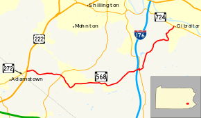
Pennsylvania Route 568 (PA 568) is an 11.60-mile-long (18.67 km) state route in Berks County in east central Pennsylvania, United States. The western terminus is at U.S. Route 222 (US 222) near Adamstown, where PA 568 continues to the southwest as PA 272. The eastern terminus is at PA 724 in the Robeson Township hamlet of Gibraltar. The route is a two-lane undivided road that passes through rural areas in southern Berks County. The route intersects PA 625 in Knauers, passes through Alleghenyville, and forms a brief concurrency with PA 10 in Green Hills. PA 568 was designated onto its current alignment by 1966. The intersection with US 222 and PA 272 at the western terminus was replaced with an interchange in 2006.
Route description
PA 568 begins at an interchange with the US 222 freeway and the northern terminus of PA 272 northeast of Adamstown in Brecknock Township, Berks County. From this interchange, the route heads east as two-lane undivided Alleghenyville Road, passing through forested areas with some fields and homes. The road continues through rural land and comes to an intersection with PA 625 in the community of Knauers. PA 568 heads southeast through forests with residential subdivisions, reaching the community of Alleghenyville. At this point, the route turns northeast as Kurtz Mill Road and curves east into a mix of farmland, woods, and homes. The road heads northeast into Robeson Township and runs through more rural areas, passing under Interstate 176 without an interchange before coming to the PA 10 junction near Green Hills. At this intersection, PA 568 turns south to briefly run concurrent with PA 10 on Morgantown Road before it splits to the east on Green Hills Road. The road winds to the northeast through forests with some homes and fields. The route follows Allegheny Creek and winds east and then north through more forested areas. PA 568 heads northeast into the residential community of Gibraltar and passes underneath the Schuylkill River Trail and a Norfolk Southern railroad line before it reaches its eastern terminus at PA 724.[2][3]
History
The present-day alignment of PA 568 was not legislated as part of a route when Pennsylvania first legislated routes in 1911.[4] By 1928, the alignment between Adamstown and Alleghenyville existed as an unpaved road.[5] The roadway between Adamstown and Alleghenyville was paved by 1940.[6] By 1953, the road between Alleghenyville and Gibraltar was paved.[7] PA 568 was designated by 1966 to run from US 222 near Adamstown east to PA 724 in Gibraltar.[8] In 2006, the intersection with US 222 and PA 272 at the western terminus was replaced with an interchange as part of upgrading US 222 to a freeway.[9]
Major intersections
The entire route is in Berks County.
| Location | mi[1] | km | Destinations | Notes | |
|---|---|---|---|---|---|
| Brecknock Township | 0.000 | 0.000 | Interchange, northern terminus of PA 272 | ||
| 2.161 | 3.478 | Hamlet of Knauers | |||
| Robeson Township | 7.611 | 12.249 | West end of PA 10 concurrency | ||
| 7.687 | 12.371 | East end of PA 10 concurrency | |||
| 11.603 | 18.673 | Hamlet of Gibraltar | |||
1.000 mi = 1.609 km; 1.000 km = 0.621 mi
| |||||
See also
 U.S. Roads portal
 Pennsylvania portal
References
- 1 2 Bureau of Maintenance and Operations (January 2015). Roadway Management System Straight Line Diagrams (Report) (2015 ed.). Pennsylvania Department of Transportation. Retrieved June 30, 2015.
- Berks County (PDF)
- ↑ Google (April 18, 2013). "Pennsylvania Route 568" (Map). Google Maps. Google. Retrieved April 18, 2013.
- ↑ Berks County, Pennsylvania Highway Map (PDF) (Map). PennDOT. 2014. Retrieved December 22, 2014.
- ↑ Map of Pennsylvania Showing State Highways (PDF) (Map). Pennsylvania Department of Highways. 1911. Retrieved January 1, 2014.
- ↑ Pennsylvania Highway Map (Philadelphia Metro) (Map). Gulf Oil. 1928. Retrieved November 8, 2007.
- ↑ Official Road Map of Pennsylvania (PDF) (Map). Pennsylvania Department of Highways. 1940. Retrieved June 24, 2010.
- ↑ General Highway Map Berks County, Pennsylvania Sheet 1 (PDF) (Map). Pennsylvania Department of Highways. 1953. Retrieved January 6, 2015.
- ↑ General Highway Map Berks County, Pennsylvania Sheet 1 (PDF) (Map). Pennsylvania Department of Highways. 1966. Retrieved December 14, 2012.
- ↑ Youker, Darrin (June 18, 2006). "The wait is over". Reading Eagle. p. A9. Retrieved January 11, 2012.