Pennsylvania Route 780
| ||||
|---|---|---|---|---|
 | ||||
| Route information | ||||
| Maintained by PennDOT | ||||
| Length: | 8.49 mi[1] (13.66 km) | |||
| Existed: | 1936 – present | |||
| Major junctions | ||||
| West end: |
| |||
| East end: |
| |||
| Location | ||||
| Counties: | Westmoreland | |||
| Highway system | ||||
| ||||

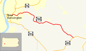
Pennsylvania Route 780 (PA 780) is an 8.49-mile-long (13.66 km) state highway located in Westmoreland County, Pennsylvania. The western terminus is at PA 56/PA 366 in New Kensington. The eastern terminus is at PA 380 in Washington Township.
Route description
PA 780 begins at an intersection with PA 56/PA 366 in New Kensington, heading east on two-lane undivided Powers Drive. The route passes through wooded areas with some residential and commercial development, turning northeast onto 7th Street. The road winds east through more woodland with development, crossing into Lower Burrell and becoming 7th Street Road. PA 780 heads east past more wooded areas of homes before winding south through a mix of fields and woods with some residences. The route curves east and enters Upper Burrell Township, passing by Penn State New Kensington before continuing through forested areas with occasional residential development. The road curves southeast and runs near the Alcoa Technical Center before passing through the community of Alcoa Center. PA 780 passes through more forests as it heads into Washington Township and becomes North Washington Road, reaching its eastern terminus at PA 380.[2][3]
Major intersections
The entire route is in Westmoreland County.
| Location | mi[1] | km | Destinations | Notes | |
|---|---|---|---|---|---|
| New Kensington | 0.00 | 0.00 | |||
| Washington Township | 8.49 | 13.66 | |||
| 1.000 mi = 1.609 km; 1.000 km = 0.621 mi | |||||
See also
 U.S. Roads portal
 Pennsylvania portal
References
- 1 2 Pennsylvania State Roads -2010. Harrisburg, Pennsylvania: Pennsylvania Department of Transportation. 2010.
- ↑ Google (May 30, 2011). "overview of Pennsylvania Route 780" (Map). Google Maps. Google. Retrieved May 30, 2011.
- ↑ Westmoreland County, Pennsylvania Highway Map (PDF) (Map). PennDOT. 2011. Retrieved May 30, 2011.