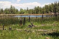
Perkins Tank
| Perkins Tank | |
|---|---|
 | |
| Location | Coconino County, Arizona, United States |
| Coordinates | 35°6′43″N 112°4′17″W / 35.11194°N 112.07139°WCoordinates: 35°6′43″N 112°4′17″W / 35.11194°N 112.07139°W |
| Primary inflows | spring |
| Basin countries | United States |
| Surface area | 3 acres (1.2 ha) |
| Average depth | 10 ft (3.0 m) |
| Surface elevation | 6,820 ft (2,080 m) |
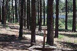
Perkins Tank
Perkins Tank is located south of Williams in North Central Arizona within the acreage of Kaibab National Forest.
Fish Species & Information
References
- Arizona Fishin' Holes, Phoenix, AZ: Arizona Game and Fish Department, 2007
|first1=missing|last1=in Authors list (help)
External links
This article is issued from Wikipedia - version of the 9/4/2015. The text is available under the Creative Commons Attribution/Share Alike but additional terms may apply for the media files.