Perth waterfront development proposals
The north shore of Perth Water on the Swan River frontage to the city of Perth in Western Australia has been frequently changed since the arrival of Europeans in 1829. Various forms and structures have appeared and been removed over the last 180 years. Jetties, ports and various forms of reclamation have moved the shore considerably into Perth Water. The main eras of reclamation were in the 1870s, 1900s, 1920s-1937, 1955–1959, and 1967.[1][2]
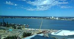
Since the 1980s various proposals have been mooted by government and others to redevelop the foreshore area. These proposals are sometimes referred to as the Perth waterfront developments and have generally focused on areas around Barrack Square and the Esplanade Reserve.
The proposals are often characterised by opposition arguing that structures and facilities in the developments will create increased separation of the central business district from the river which will further reduce access to the amenity.[3] Conversely, others argue that the city/river vista to motorists along Riverside Drive will be spoiled. Some proposals have included traffic tunnels or landbridges to enable the city to re-attach to the river.
Riverside Drive history
The laying of Riverside Drive as a subsistence project in 1937 provided an opportunity for the City of Perth to negotiate for control of the entire foreshore, which had previously been managed by the State Gardens Board.[4] Designed as a boulevarde, the Drive encouraged tourists and Perth residents alike to travel along the river, in a 20th-century version of the 18th and 19th century tradition of promenading.[5] Riverside Drive was widened when works on the Mitchell Freeway interchange commenced in the late 1950s.[6] In the early 1960s, a proposal to build a major freeway along the foreshore was being prepared by consultants for the Main Roads Department. Perth City Council, town planner Paul Ritter, and others, argued that traffic volumes didn't warrant the plan, and that the new north-south freeway system was adequate. Visiting architect Theodore Osmundson suggested in 1968 that the city ring freeway project being considered would "encircle[s] the city like an iron collar [which] can only eventually choke the central city to death".[7] Riverside Drive was further modified in the 1970s to provide access to the Mitchell Freeway and again in the late 2000s as part of the sinking of the railway to William Street.
CityVision, 1988
|
| |
|
| |
|
| |
|
| |
|
|
CityVision is an urban planning think tank and advocacy group.[8] In 1988 it published its first foreshore redevelopment scheme which included a focus on development along Langley Park to the east, as well as a number of pedestrian overpasses crossing Riverside Drive.
The CityVision group has submitted a number of other designs for public discussion since then.
Lawrence Government, 1990
In December 1990, Premier Carmen Lawrence announced plans for an international design competition for a foreshore redevelopment.[9][10] The competition had a first prize of $50,000 which was awarded to U.S. design firm Carr, Lynch, Hack and Sandell.
The winning design included a cable car from Barrack Street to Mount Eliza and Kings Park.
City of Perth, 2005–2030
A 2004 plan endorsed by the City of Perth in 2005 titled "Western Foreshore Scenario 2 – City of Perth 2005–2030" shows a more westerly development towards the Narrows Bridge with minimal realignment of Riverside Drive.[11]
Carpenter Government plans, 2008
In February 2008, Premier Alan Carpenter announced plans for a $300 million redevelopment including multiple high-rise buildings with joint private and public funding.[12]
The proposal included realignment of Riverside Drive.
He stated that work would start before 2012 if his government was re-elected. The then opposition leader Colin Barnett objected to the plans, saying "people did not want skyscrapers on the city foreshore and the plan would create an exclusive enclave for corporations and rich apartment owners".[13]
The Carpenter government was defeated at the 2008 election.
Barnett Government plans, 2011
In February 2011 Premier Colin Barnett and Perth Lord Mayor Lisa Scaffidi confirmed plans for a new project and funding which included $270 million from the 2011/12 state budget.[14][15] The project will include construction of an artificial inlet where the Esplanade Reserve now stands, and modifications to the surrounding environs including Barrack Square. Nine large building sites will be constructed for residential apartments, commercial offices and retail space.
References
- ↑ Seddon, George; Ravine, David, 1955– (1986), A city and its setting : images of Perth, Western Australia, Fremantle Arts Centre Press, ISBN 978-0-949206-08-4
- ↑ Lise Summers, Reclamation for recreation
- ↑ "Who cares if it has an umbilical cord, just get it done (Opinion)". WAToday. 16 February 2011.
- ↑ Stannage, Tom (1979). The people of Perth.
- ↑ Faro, C. (1998), "To the lighthouse!The South Head Road and place-making in early New South Wales", Journal of the Royal Australian Historical Society, December
- ↑ "Esplanade Reserve - Assessment Documentation" (PDF). Heritage Council of Western Australia. p. 8. Retrieved 16 June 2012.
- ↑ Alexander, Ian; Phil McManus (1992). "A New Direction for Perth Transport?". Urban Policy and Research. 10 (4): 6–13. doi:10.1080/08111149208551528.
- ↑ "CityVision home page". Cityvision. Retrieved 7 March 2012.
- ↑ "Speech by Carmen Lawrence, Perth Foreshore competition launch". Curtin.ede.au. 9 December 1990. Retrieved 9 March 2012.
- ↑ Taylor, Robert (14 December 2009). "Another Premier, another foreshore plan". The West Australian. Retrieved 9 March 2012.
- ↑ "Better Planning". thecitygatekeepers.com.au. Retrieved 7 March 2012.
- ↑ "Carpenter announces new waterfront plan". ABC News. 14 February 2008.
- ↑ Weller, Richard (2009), Boomtown 2050, UWA Publishing, ISBN 978-1-921401-21-3 - quotes David Hatch, The West Australian, 3 September 2008 : The Perth Waterfront Project and the State Government's Network City planning policy would be scrapped under a Liberal government, Colin Barnett said yesterday. The Liberal leader said people did not want skyscrapers on the city foreshore and the plan would create an exclusive enclave for corporations and rich apartment owners.
- ↑ "Latest Perth waterfront redevelopment gets a cash boost". WAToday. 15 February 2011.
- ↑ "City waterfront plans revealed"
Further reading
- Bolleter, Julian (2015). Take me to the River: The story of Perth's foreshore. Crawley, WA: UWA Publishing. ISBN 9781742586489.
Coordinates: 31°57′33″S 115°51′29″E / 31.95917°S 115.85806°E