Pessegueiro Island
| Pessegueiro Island (Ilha Pessegueiro) | |
| Island (Ilha) | |
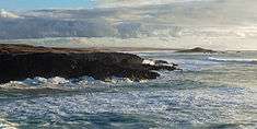 The island of Pessegueiro as seen from the village of Porto Covo, during a winter storm | |
| Official name: Ilha do Pessegueiro | |
| Name origin: pessegueiro, Portuguese word for peachtree; literally "island of the peachtree" | |
| Country | |
|---|---|
| Region | Alentejo |
| Subregion | Alentejo Litoral |
| Location | Vicentine Coast, Atlantic Ocean |
| Municipality | Sines |
| Civil parishes | Porto Covo |
| Landmark | Fort of Pessegueiro Island |
| Highest point | |
| - elevation | 21 m (69 ft) |
| - coordinates | PT 37°50′0.57″N 8°47′51.22″W / 37.8334917°N 8.7975611°W |
| Lowest point | Sea level |
| - location | Atlantic Ocean |
| - elevation | 0 m (0 ft) |
| Length | .20 km (0 mi), West-East |
| Width | .32 km (0 mi), North-South |
| Biomes | Temperate, Mediterranean |
| Geology | Alkali basalt, Tephra, Trachyte, Trachybasalt |
| Orogeny | Volcanism |
| Period | Holocene |
| Ethnic groups | Portuguese |
| Wikimedia Commons: Ilha do Pessegueiro | |
| Statistics from INE (2001); geographic detail from Instituto Geográfico Português (2010) | |
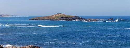
Pessegueiro Island (Portuguese: Ilha do Pessegueiro), literally island of the Peachtree, is a small island/islet located along the southwest coast of the civil parish of Porto Covo in the municipality of Sines. The island and the adjacent coast are part of Southwest Alentejo and Vicentine Coast Natural Park, but Pessegueiro island is also notable for the 15th-16th century fort located at its centre and Roman ruins along the coast.
History
Historically, the island was first occupied by the Carthaginians before the Second Punic War (218-202 BCE).
At the time of the Roman conquest of Hispania, the island hosted a small fish processing centre, as determined by archaeological excavations which discovered the remains of salt tanks along the southern coast.
To help defend against privateers, the natural anchorage was extended at the time of the Iberian Union with an artificial rock barrier connecting the island of Pessegueiro to the coastline. In 1590, construction began on the Fort of Pessegueiro Island, which came to occupy a dominant position on the island, with the purpose of providing military support to a fort on the mainland. Work on the project was halted in 1598 in order to construct the Fort of Vila Nova de Milfontes.
The legend of Our Lady of Queimada
According to tradition, in the middle of the 18th century, Barbary pirates arriving on the island from Algeria and Morocco encountered a Christian hermit who was maintaining a chapel dedicated to the Virgin Mary. The pirates killed the monk, looted the chapel and threw her statue into the flames.
Later the inhabitants of Porto Covo buried the Christian hermit, but could not, at first, find the sacred image. Deciding to search the entire island, they finally found the statue within a burned bush but unharmed by the fire: the image became known as the Queimada (Burnt Virgin). The statue was removed to the mainland, one kilometre from the island, where a new chapel was built, known as the Chapel of the Burned Virgin (Portuguese: Capela de Nossa Senhora da Queimada), becoming a destination for pilgrimages.
Geography
Located 300 metres (330 yd) from the coast by a channel, it is situated south of the parish seat of Porto Covo, southwest of a small inlet used by fishing boats.[1]
Part of the Southwest Alentejo and Vicentine Coast Natural Park it is migratory stop and hatchery for many marine bird species, some on the verge of extinction, including seagulls, cormorants and carrion crows.[2]
References
- Notes
- ↑ Sailing Directions (Enroute): West Coast of Europe and Northwest Africa (PDF) (Pub.143), Springfield, Virginia: National Geospatial-Intelligence Agency, 2011, p. 142, retrieved 14 January 2012
- ↑ "Ilha do Pessegueiro" (in Portuguese). Sines, Portugal: Câmara Municipal de Sines. 2011. Retrieved 14 January 2012.